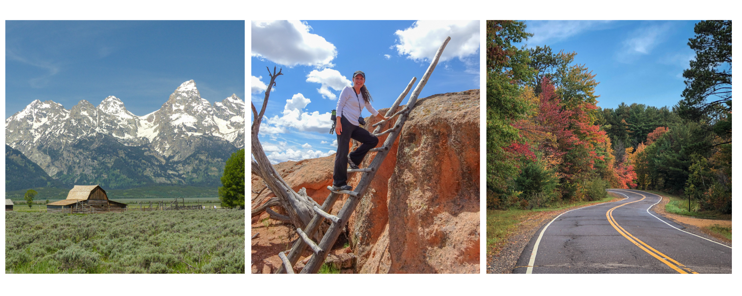
When Al and I awoke to a beautiful and calm morning, we were quick to agree on an early morning hike …. early meaning out the door around 8:00 a.m. The previous two days kept us indoors due to high gusting winds. Ah, those pesky winds.

But while a sculptor may use tools like a chisel or rasp, Mother Nature sculpts with wind, water and time. Without all the annoying sandblasting wind, I wouldn’t have all this perplexing scenery to go gaga over. So I endure the bad along with the good and plan our excursions around the weather.
An easy hike
With an eagerness to get out and explore, we hopped in the truck and traveled about twenty miles north of the Arizona – Utah border. This trailhead and hike will lead us toward what is known as the Toadstools.
This relatively easy and well-marked short trail starts out in a sandy wash.

Therefore, it’s probably not a good idea to hike this trail after a rainstorm. As it was, we encountered a few muddy patches and it hadn’t rained in days.

The trail is pretty nondescript until you crest a hill and are greeted with the first and most impressive toadstool.

These mushroom-like shaped rocks had Al and me tilting our heads in wonder. Bewildered, we were duly entertained and found ourselves drifting from one interesting rock formation to another.

By starting the day early, we literally had the place to ourselves ….. that is, for at least fifteen minutes ….. it was ours, and ours alone, and we loved every minute.
We found the land very strange and a bit surreal. We briefly felt like we were on some old movie set like Star Wars or Game of Thrones … perhaps, we even spotted ET!


Not having to share this landscape with other visitors allowed Al and me to have fun with the self-timer on the camera. Yeah, there were a few laughs and retakes as I didn’t always run and pose quick enough. It was me against the ten-second timer and many times the timer one 😆
If you find yourself visiting Page, Arizona, and looking for a fun way to spend an hour or two, consider visiting the Toadstools. It’s easy to get to. It’s an out-and-back hike and is less than 2 miles in total. But be sure to linger amongst the toadstools and stroll in all directions before returning to the trail. You never know what else you might see!

A slot canyon hike with an obstacle
The weather was dictating our schedule and as much as we didn’t want to embark on a well-known trail on a Saturday, we did exactly that (April 14, 2018). This time we were out the door by 7:30 a.m. (Arizona time). After all, we had about a one-hour drive in front of us to get to the Wire Pass trail located in southern Utah.

Upon arriving at the trailhead, we found plenty of room to park. After grabbing our packs and paying the $6 per person trail fee, we were eagerly on our way. Once again our hike started off in a sandy wash which continued for about the first mile.


Eventually, the landscape started to get interesting as the red rocks began to surround us. We entered a small short slot, of sorts, before the rock walls opened again. I felt the canyon was teasing me, and giving me a little taste of what was to come.
Not long afterward, the fun began.


Before deciding to hike Wire Pass Canyon, I had done a fair amount of research about the trail. Al and I do not consider ourselves avid hikers. As such, I wanted to make sure we didn’t get ourselves into a situation beyond our abilities.
I read somewhere that there is one major obstacle in the slot …. an eight-foot drop. Hmm, sliding down might be doable, but since this was an out-and-back hike, I had concerns about getting back up that 8-foot drop. Therefore, Al and I agreed ahead of time that we’d probably turn around at that point. (We later learned that there is indeed a go-around trail, but the best part of the slot canyon would be missed. More info about Wire Pass Canyon and the surrounding area is available at the visitor center in Kanab, Utah.)

Guess I was wrong!
Before I knew it, Al had negotiated the drop. Of course, I’m always lagging behind with my camera as I snap away. Turns out, someone had placed some rocks and an old tree trunk at the base of the drop to aid in the navigation.
Al was encouraging and quick to help me on my scramble down. I have to admit, I was really glad he was game and wanted to hike further. I felt this obstacle showed up rather quick in the slot canyon. Actually, way too soon in my opinion, and at that point, there was no way I wanted to turn around. I wanted, I needed to explore further!


Once over the drop, the canyon proceeded to get narrower and deeper. The lack of light made it difficult to photograph, but oh-so fun to hike. The slot canyon was long and deep and we were glad we didn’t need to pass any other hikers. Eventually, the canyon opened up and we were at the intersection where the Wire Pass trail meets the Buckskin Gulch trail.

Buckskin Gulch is considered the longest and deepest slot canyon in the U.S. Its towering walls make it difficult for the sun to reach the canyon floor and hikers can expect to encounter water and mud. We were here in mid-April and according to hikers exiting the slot, water was waist-high in one direction and knee-high in the other, and the water was very very cold.

My curiosity got the better of me and I had to peek around the corner, but I didn’t get very far before I felt my shoes sink into the mud. I walked Buckskin Gulch in both directions before that mud had me retracing my steps back to the Wire Pass trail. We weren’t prepared or equipped to hike in water nor did I have the inclination.


With Al antsy to keep moving, I quickly took some photographs of the Buckskin Gulch trail and then we started our return trek.
There was a time when I would prefer and seek out loop trails instead of out-and-back hikes, but I’ve discovered when hiking in the opposite direction, the scenery can look quite different on the exact same trail, and I found that to be very true on the Wire Pass Trail.


The scenery in the canyon was spectacular and it looked as though we were hiking a completely different trail on our return. Ah, but this was the same trail, and therefore, we would need to climb up that eight-foot drop. Would I have a problem, I wondered?
I decided to go first. I tried one foot there. Hmm, that didn’t work. How about this foot there? No, that wouldn’t work. At barely 5’5″ tall, no matter how hard I tried, I couldn’t get a firm hold on anything that would allow me to get high enough so I could fling my body over that boulder.


“If I could just hoist myself higher, I’d be able to crawl over that boulder”. Nope! I couldn’t do it. The sandstone walls were slick and didn’t provide any leverage. I couldn’t get a firm grip on that boulder. I could feel a little panic build up inside me. I realized the only other way out of the canyon was hiking miles via the Buckskin Gulch trail that was filled with water 😥 (Remember, at that point, I didn’t know there was actually another way out.)
Hopefully, Al’s 6’3″ plus frame would be tall enough to get us out of here. Fingers crossed!
At that point, we both put on our gloves to help grip the boulder better (yep, we came somewhat prepared). After Al struggled a bit, I lent my hand as another foothold for him, and then up and over he went. Whew! Now that he was at the top, he helped pull me up and over.
This was the only area in the slot canyon where we ran into other hikers. They were coming down, and all appeared to be about half our age. Some navigated the drop like mountain goats, while others were more tentative like yours truly. Unfortunately, I didn’t get a chance to watch anyone else climb back up this obstacle.

With a new-found spring in our step and a few pats on the back later, Al and I took our time hiking the rest of the way back to the truck. I found the scenery even more amazing on our return trek and I wanted to savor it.
 The Wire Pass Canyon Trail is a relatively easy hike with the exception of that one major obstacle. Al and I promised each other that we’d hike it again next time we’re in the area, but we’ll be sure to bring rope or some other aid in climbing back up that drop.
The Wire Pass Trail is about 3.4 miles round trip. All in all, the hike took us about 2 1/2 hours, but that included lots of stops for photos and lingering on the Buckskin Gulch trail. My Fitbit registered 4.3 miles.
This was a leisurely stroll for us through a fascinating canyon. It was a beautiful day and a fantastic hike that we’d repeat in a heartbeat. 😊


Additional tidbit – near the Wire Pass and Buckskin Gulch intersection is an interesting arched alcove with a hanging garden. Along a nearby wall are some petroglyphs…. signs of an ancient civilization. We also noticed water weeping down the walls in the narrowest part of the slot.


Finding the trailhead – From Page, Arizona, take US 89 into Utah for about 34 miles before turning left on House Rock Valley Road (near mile marker 25). The turnoff is in the middle a 50 mph right-angle curve making it a little precarious with impatient traffic. The trailhead is 8.5 miles down this gravel road. From Page to the trailhead, the drive took us close to an hour.
Come prepared for this remote hike and pay attention to the weather. Next time we’ll be sure to bring rope in addition to our gloves. Our clothing and hiking shoes were perfect, and of course, we brought plenty of water and snacks.
Happy trails,


75 responses to “Toadstools and a Slot Canyon”
[…] I had read on blogs and various trail reviews that there was one big obstacle getting through the canyon – an 8 foot drop that required hikers to sort of blindly reach down for footing and then continue down. I didn’t think much of it when I read about it, but as soon as I was standing there trying to figure out how to make it down safely, I froze. (Ingrid wrote about the obstacle and has some photos on this post.) […]
LikeLike
We stopped at the Toadstools on our way from Arizona back to Alberta. It was late in the day and though the heavy dark clouds weren’t the best for photos, the Toadstools were still fantastic! I wonder how many years or decades it will be before they topple over!
LikeLike
[…] can I say about the hiking possibilities around northern Arizona and southern Utah? …. Toadstools, slot canyons, mini waves, a rim trail, a hanging garden, and Horseshoe Bend …. and those are […]
LikeLike
What an astounding adventure Ingrid. Glad to hear you and Al made it over the obstacles all right. Like you I would have not wanted to stop exploring although one definitely needs to keep safety in mind at all times. those toadstools are jaw dropping. Makes one wonder how that is even possible?
LikeLike
The landscape around this part of the country is perplexing and surreal. It has been a delight exploring. So many adventurous things to do around here!
LikeLike
I loved your photographs. Not only the place has the charm, also the photography skills make the place more beautiful and provoking. Thanks for sharing this post.
LikeLike
Thank you! Stunning landscape makes it easy to take great photos. Thanks for stopping by and commenting.
LikeLike
This look s amazing and you’ve done such a wonderful job in relating all the right to jog back to us! We are heading to MAlaysia in July and there’s a short hike in Penang we want to do. With a 3 year old and 16 month old I’ve been investigating the idea with some trepidation, but reading this has me way more motivated to get into the hiking spirit!
LikeLike
Whoa! You are way more adventurous than I ever was traveling with small children. We regained our travels once our children were 4 and 6 (well potty trained). I think what you’re doing is wonderful and training the children to be flexible and exposing them to other lands. Have a great time. BTW… my son’s name is Logan 😊
LikeLiked by 1 person
Looks like a perfect hiking trail. Though I admit it will be a bit hot to trek here. I’m used to Himalayan weather which means rain is likely post-noon!
LikeLike
Yep, probably on the warm side for you. This area is only at about 4500 feet in elevation and does start to get pretty warm by May. In the last 30 days, we’ve seen rain twice. I guess that’s why it’s consider high desert.
LikeLiked by 1 person
We did the same two hikes when we were just there but in the opposite order. Made it through 17 “puddles” in Buckskin, some up to my waist before turning around because we were frozen! So beautiful and worth it. I did not know about the choke/drop in Wire Pass and had a hiking skirt on. Made things really interesting!
LikeLike
Brrrr …. that water had to be cold. We talked to a group of Asian tourists as they excited Buckskin Gulch and they all kept saying ‘don’t do it … too cold’, but they were prepared. Fun group! I love hiking skirts but knew I’d be potentially crawling and had already banged up my legs at Waterholes thus cargo pants fit the bill. I’m sure your attire was entertaining climbing over that boulder 😉
LikeLiked by 1 person
Beautiful!y photographed! another must go to destination.
LikeLike
Thanks Tim – we’re having a great time in the area, but not a fan of all the tourists. Gotta take the good along with the bad as you well know!
LikeLike
We will have to make notes to visit these beautiful places the next time we are in the Page area. What wonderful shots and I am sure more enjoyable without guides moving the crowd along. I can see why you have extended your stay. We too left wanting to stay longer.
Thanks for sharing.
LikeLike
By extending our stay, we’ve been able to explore some less known spots and enjoy hikes without the masses which is a treat around here. We’re already looking forward to a future visit 😊
LikeLike
The Toadstool hike so much fun. It’s one of those places where you keep discovering new things as you wander around the area. Wire Pass looks like so cool. It was on the list for this year before we got side track with a house:) We finally started carrying a rope. We’ve only had to use it once. It is nice knowing that we have that little help we might need. It isn’t a thick rope but sturdy and just enough to give you some support to let yourself down or pull yourself up. Beautiful photos of this awesome adventure:)
LikeLike
Thanks Pam and I think we too will add a rope to our pack if we plan on doing more hikes like this. We’ve definitely stepped outside of our comfort level around here and we’re loving it. Wire Pass was a fun hike and I would’ve enjoyed exploring more of Buckskin BUT not in water. We’ve talked about coming back in September but not sure it’ll be any better considering August is monsoon season. Guess we’ll play it by ear.
LikeLike
Great photos! Reminds me of the Tent Rocks in New Mexico. I have never been to Utah, but it seems like too much to see in one trip for this working girl…
LikeLike
One of my favorite hikes – Kasha-Katuwe Tent Rocks. There is a similarity with slot canyons but each offers unique scenery. You MUST visit Utah! You won’t be disappointed 😊
LikeLike
Wow! Wow! Wow! It would be helpful if you numbered your photos – then folks could comment on a particular image. I always like the shots with people in the landscape. My favourite is one of the first ones of you and hubby posing with some of the wind-carved statues!
LikeLike
Haha …. thank you. I’m not sure I could begin to number all the photos I post. Adding a person seems to give scale to this unusual terrain and I’ve been trying to do exactly that a bit more. Such fun!
LikeLiked by 1 person
Haha – Agree that you’d probably go nuts numbering them all!
LikeLiked by 1 person
Just.plain.wow! You have got this hiking thing down pat, lady. And the great photos are making me want to go 🙂
LikeLike
You would love visiting Glen Canyon National Rec Area and that camera of yours would be working in overdrive. Do add northern AZ to your ‘list’.
LikeLiked by 1 person
Oh it’s there! It’s there!
LikeLiked by 1 person
Hi Ingrid! Wonderful post and fabulous photos! I’m not a fan of squished spaces, but I would probably try it just to see the amazing sites in your photos.
LikeLike
Thank you! I too am not a fan of small places, but that narrowest part of the slot canyon wasn’t too long and was way too much fun not to hike. Highly recommend a visit to northern AZ / southern UT… stunning!
LikeLiked by 1 person
definitely on my list!
LikeLike
Both hikes look absolutely stunning. A good reason to always hike with a partner. Thanks for sharing this wonderful blog post. We can’t wait to visit there ourselves one day.
LikeLike
We’ve been having a fantastic time in the Glen Canyon National Recreation Area and are already looking forward to returning. So many fun hikes and sights…. the more the merrier!
LikeLike
I can’t believe we were in that area and did not see the Toadstools or the slot canyons! Now we can add two more attractions to visit next time we are in the area.
LikeLike
By spending a month in the area, we’ve had the opportunity to discover a bunch of gems … some hidden and some well-known. We’re savoring those less known spots and the rare solitude in this tourist heavy location.
LikeLike
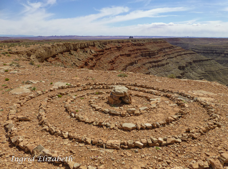
The varying colors of the rock layers amazes me and I have to wounder what was going on on earth when the various layers were laid down.
LikeLike
It’s a perplexing sight that leaves me bewildered and feeling insignificant. Mother Nature is a wonder!
LikeLike
You got some really nice shots.
LikeLike
Thank you …. the camera is working hard this month 😊
LikeLiked by 1 person
What an awesome time you are having with Page as the camp. Two more areas to check out if we are back up that way. Great post!
LikeLike
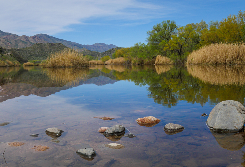
Very interesting landscape around here, but the lake is the real jewel. I’m dying to get out on the water, especially as it’s finally starting to warm up. You’ll definitely want to put Page on your radar.
LikeLike
We spent 5 days there last spring and had a ball. We rented a boat for a day and cruised out to Rainbow Arch. That was spectacular. We keep talking about renting a houseboat for a week and really exploring the lake. Sure wish we were there this week when its 96 again here in the valley.
LikeLike
Perfect boating weather this week at Lake Powell and could sure use friends to share a boat ride 😉 This is actually the first week I felt it was warm enough to get out on the water.
LikeLike
If I were flying to KY to see my Mom tomorrow I would be all over that and outta this hot valley weather for sure!!!
LikeLike
Yeah, that heat can take some getting used to. Safe travels and enjoy your visit with your mom.
LikeLike
Absolutely awesome post! We just arrived in Page. Hiking Canyon X tomorrow (Monday). Beautiful and stunning scenery in this area. Thank you for all of the incredible info!
LikeLike
Welcome! The weather is going to be beautiful all week. Seems you picked the right week to visit. Enjoy!
LikeLiked by 1 person
Thank you! We should have budgeted more time here!
LikeLike
We’ve extended our stay twice and are still discovering new sights. As the weather warms, I’m dying to get out on the water. I may have to take one of those tour boats yet!
LikeLike
Anxiety mounted as I read about your attempts to climb up the 8’ drop – but your were at home and telling the tale, so you must have found a way. I was pleased to read that you made it out unscathed and retraced your original steps. I remember a time when we were hiking down a gorge and Paul suggested we turn back at one point saying I’d never manage to get back up. If I could get down, I’d get back up I determinedly declared. Ha, famous last words – fortunately two other able bodied hikers arrived as we trying to find foot and hand holds on the sloping platform rock. Paul managed it fine, but it took the three of them to safely get me back up to that rock. Lesson learned!
LikeLike
Yes, sometimes we need to learn these lessons the hard way. I’m glad Al managed to get over that obstacle and then help me, but we also knew there were others on the trail that might be willing to help. I’m really glad we made the excursion because the sight and experience were so worthwhile 🙂
LikeLiked by 1 person
Another great hike…thanks for the tips!
LikeLike
Thank you – it’s one of our favorites!
LikeLike
First off, congratulations you did it! I’m impressed. Secondly, that wire pass trailhead parking lot is the same one with the wave, and had I given you the map you could have segway there, just saying 🙂 Thirdly, I don’t think I can get out of that slot! so thanks for the hike. Love all your photos, great shots of those deep canyons.
LikeLike
The Wave….the one that’s impossible to get permits for? Perhaps this is just as beautiful?
LikeLike
I was very lucky to snag a permit last year. And yes it’s out of this world and check my post here
LikeLiked by 1 person
Thanks for sharing this blogpost. Since it’s closed to comments, just wanted to extend best wishes to Steve, since this was last year & I’ve seen many posts since…hoping all is well now. I’m glad you were one of 20 to get a permit…seems it was meant to be! The universe is wonderful !
LikeLiked by 1 person
Thank you ML. Yes, I knew it was the same parking lot for the Wave and we saw where the trail split for Coyote Buttes. I thought of you as we passed by. Sure you could make it out of that slot …. with the help of friends 😁
LikeLike
Both great hikes, so glad you got to do them…too bad about Buckskin Gulch though, something for next time in a dryer season. Great photos, brings back memories of our trip there 2 years ago.
LikeLike
I’m glad we were able to hike those trails as well. We were going to try Wiregrass Saturday but had a good amount of rain on Friday so just returned to the Rimview Trail. Love those views.
LikeLike
Great pics! We did the Toad Stools earlier this year. Thanks for the tour on the others, we’ll add those to our to do list on our next visit. Safe travels!
LikeLike
We’re having a great time hiking around here. We’re partial to shorter hikes and we’ve found some great trails. We’ve enjoyed the area so much that we’ve extended our stay twice. Ah, the beauty of a home on wheels!
LikeLike
Two more fantastic and strikingly beautiful hikes! Funny you mention a loop trail compared to out and back. I’m exactly like you! I used to complain about out and back, preferring a loop trail, only to discover how different the scenery looks on the way back. No more complaining now! 🙂
I see that Wire Pass is in the National Monument. If one has a NP pass, would the $6 per person for the slot canyon hike be waved?
LikeLike
The land around here is so unique that it looks different from all angles. Very fun! Unfortunately, that fee is a trail fee so it doesn’t matter if you have a NP pass. It was an amazing hike and worth the $6.
LikeLike
You and Al are awesome, Ingrid. The story of conquering that 8′ drop is so inspiring–your experience, preparedness, level-headedness, and ingenuity that carried you through. And I like how that trail was so different coming back, even though it was the same thing. This is a marvel of some trails. The first hike gave me a smile, seeing you both having so much fun with the trail to yourselves, and being silly and posing. Great stories, superb photos, and impressive intrepid spirits.
LikeLike
Thank you Jet for your kind words. We’ve been having such a fantastic time in northern AZ that we’ve extended our stay twice. So much to see and do around here and we haven’t even gotten out on Lake Powell…. sigh!
LikeLiked by 1 person
What a landscape! : I like your, “Mother Nature sculpts with wind, water and time”. How true, and how awe-inspiring.
Have a wonderful Sunday,
Pit
LikeLike
Thank you Pit. It is incredible landscape that continues to awe me!
LikeLike
This landscape is truly awe-inspiring!
LikeLike
The Wire Pass Canyon trail photos are spectacular! The morning light makes the canyon colors vibrant. You really caught the vibe..the toadstools were magnificent. Your photos rock!!
LikeLike
Thank you Nancy … haha, love your play on words! My camera has definitely been getting a good workout.
LikeLike
Great narrative! I really enjoy your blog.
I can relate to the “panic” feeling, been there, done that. Utah has some amazing hiking but you have to pay attention to the equipment needed and the experience required on a lot of trails. It can be easy to get into something beyond your ability to get out of.
LikeLike
Totally agree with you Timeswandering, and in fact, one reason I love Ingrid’s blog and great photos is because she attracts followers like you who also have great photos and stories on their blogs! Just signed up for yours 🙂 You’ve got quite an eye and the patience for capturing some great wildlife photos.
LikeLike
Thank you – and yes very true about knowing one’s ability. There’s a few hikes on my list I’d love to attempt, but logic rules. Thus, I’ll need to pass and settle for other hikers photos.
LikeLike
You’re not alone! Wire Pass was one of the first slot canyons I hiked in and my climb over that choke stone was extremely awkward! So much fun though, right?
LikeLike
Agree … fun! Oh, how I wanted to climb up over that boulder without help, and trust me, I tried 😄
LikeLiked by 1 person