Toadstools and a Slot Canyon

When Al and I awoke to a beautiful and calm morning, we were quick to agree on an early morning hike …. early meaning out the door around 8:00 a.m. The previous two days kept us indoors due to high gusting winds. Ah, those pesky winds.

Toadstools

But while a sculptor may use tools like a chisel or rasp, Mother Nature sculpts with wind, water and time. Without all the annoying sandblasting wind, I wouldn’t have all this perplexing scenery to go gaga over. So I endure the bad along with the good and plan our excursions around the weather.

An easy hike

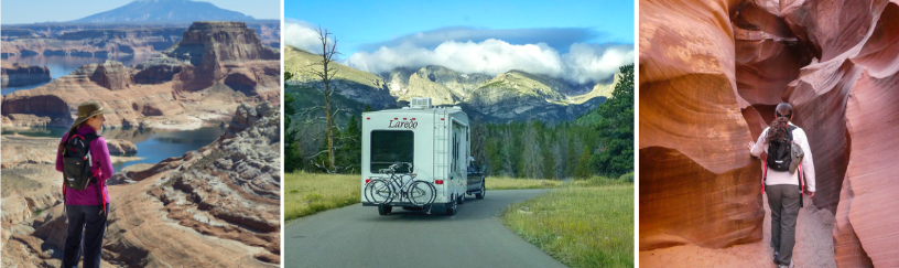
With an eagerness to get out and explore, we hopped in the truck and traveled about twenty miles north of the Arizona – Utah border. This trailhead and hike will lead us toward what is known as the Toadstools.

This relatively easy and well-marked short trail starts out in a sandy wash.

Therefore, it’s probably not a good idea to hike this trail after a rainstorm. As it was, we encountered a few muddy patches and it hadn’t rained in days.

the trail is clearly marked

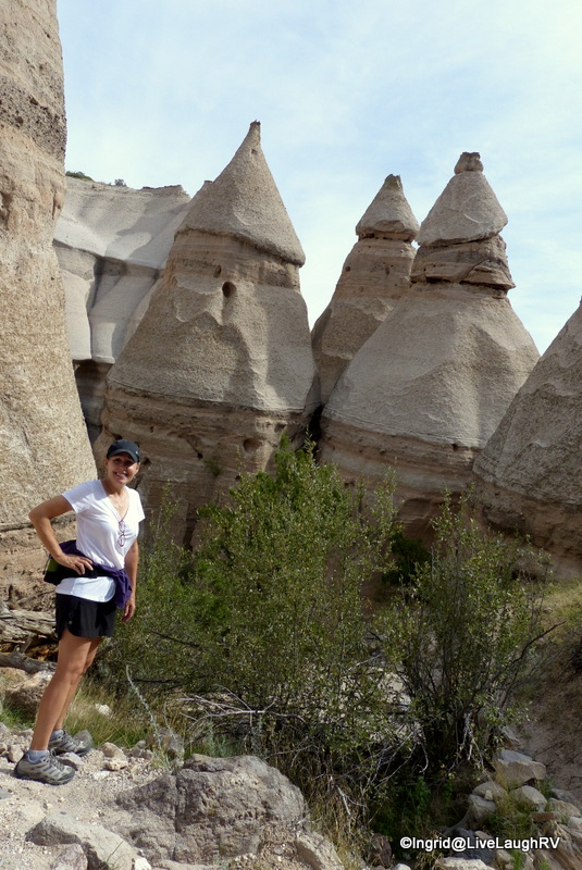
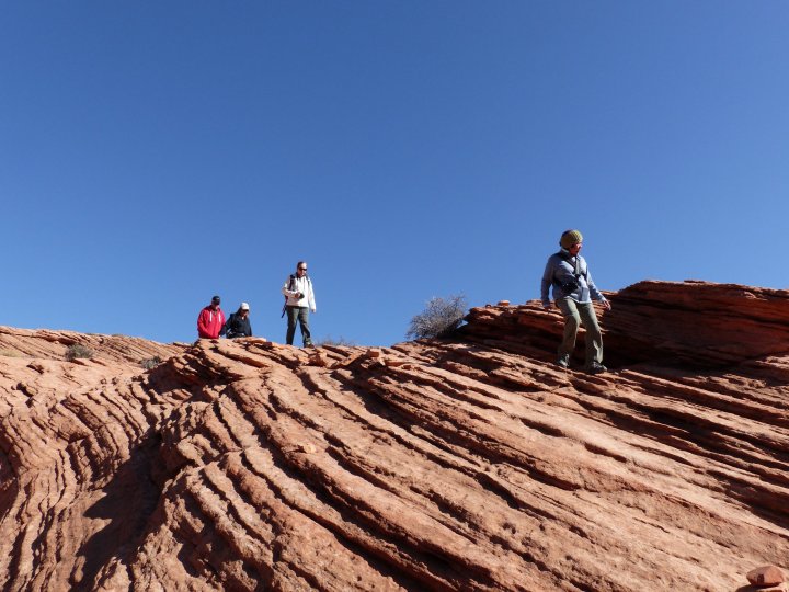
The trail is pretty nondescript until you crest a hill and are greeted with the first and most impressive toadstool.

These mushroom-like shaped rocks had Al and me tilting our heads in wonder. Bewildered, we were duly entertained and found ourselves drifting from one interesting rock formation to another.

By starting the day early, we literally had the place to ourselves ….. that is, for at least fifteen minutes ….. it was ours, and ours alone, and we loved every minute.

We found the land very strange and a bit surreal.  We briefly felt like we were on some old movie set like Star Wars or Game of Thrones … perhaps, we even spotted ET!

Not having to share this landscape with other visitors allowed Al and me to have fun with the self-timer on the camera. Yeah, there were a few laughs and retakes as I didn’t always run and pose quick enough. It was me against the ten-second timer and many times the timer one 😆

If you find yourself visiting Page, Arizona, and looking for a fun way to spend an hour or two, consider visiting the Toadstools. It’s easy to get to. It’s an out-and-back hike and is less than 2 miles in total. But be sure to linger amongst the toadstools and stroll in all directions before returning to the trail. You never know what else you might see!

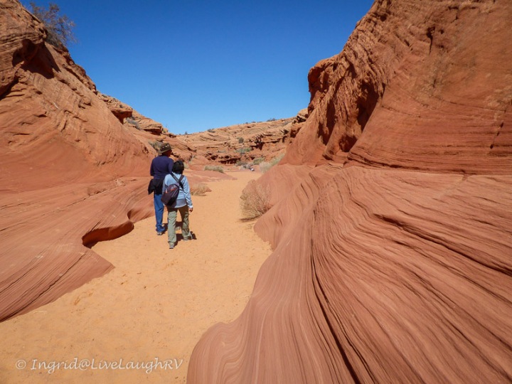
A slot canyon hike with an obstacle

The weather was dictating our schedule and as much as we didn’t want to embark on a well-known trail on a Saturday, we did exactly that (April 14, 2018). This time we were out the door by 7:30 a.m.  (Arizona time). After all, we had about a one-hour drive in front of us to get to the Wire Pass trail located in southern Utah.

Wire Pass Trail Utah

Upon arriving at the trailhead, we found plenty of room to park. After grabbing our packs and paying the $6 per person trail fee, we were eagerly on our way. Once again our hike started off in a sandy wash which continued for about the first mile.

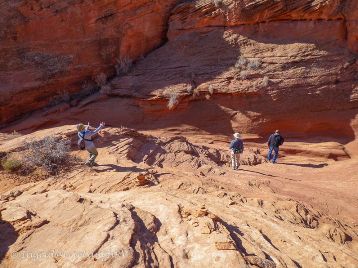
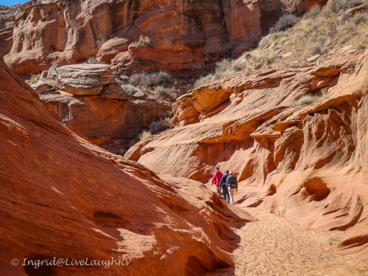
Eventually, the landscape started to get interesting as the red rocks began to surround us. We entered a small short slot, of sorts, before the rock walls opened again. I felt the canyon was teasing me, and giving me a little taste of what was to come.

Not long afterward, the fun began.

Before deciding to hike Wire Pass Canyon, I had done a fair amount of research about the trail. Al and I do not consider ourselves avid hikers. As such, I wanted to make sure we didn’t get ourselves into a situation beyond our abilities.

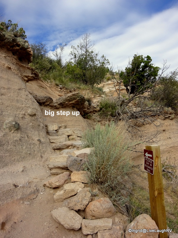
I read somewhere that there is one major obstacle in the slot …. an eight-foot drop. Hmm, sliding down might be doable, but since this was an out-and-back hike, I had concerns about getting back up that 8-foot drop. Therefore, Al and I agreed ahead of time that we’d probably turn around at that point. (We later learned that there is indeed a go-around trail, but the best part of the slot canyon would be missed. More info about Wire Pass Canyon and the surrounding area is available at the visitor center in Kanab, Utah.)

This is the major obstacle on the trail – an 8′ drop

Guess I was wrong!

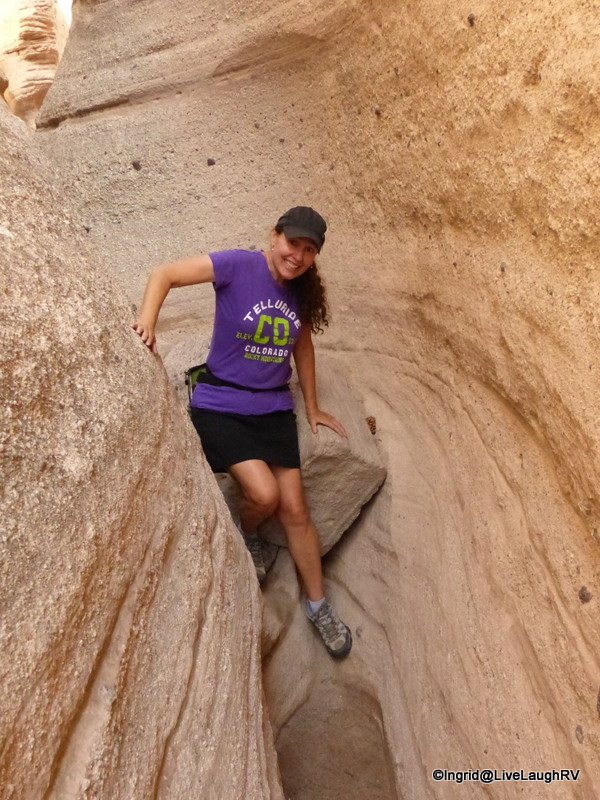
Before I knew it, Al had negotiated the drop. Of course, I’m always lagging behind with my camera as I snap away. Turns out, someone had placed some rocks and an old tree trunk at the base of the drop to aid in the navigation.

Al was encouraging and quick to help me on my scramble down. I have to admit, I was really glad he was game and wanted to hike further. I felt this obstacle showed up rather quick in the slot canyon. Actually, way too soon in my opinion, and at that point, there was no way I wanted to turn around. I wanted, I needed to explore further!

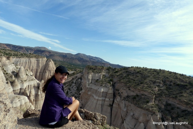
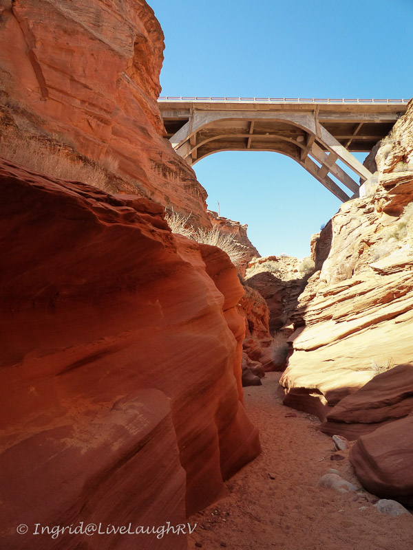
Once over the drop, the canyon proceeded to get narrower and deeper. The lack of light made it difficult to photograph, but oh-so fun to hike. The slot canyon was long and deep and we were glad we didn’t need to pass any other hikers. Eventually, the canyon opened up and we were at the intersection where the Wire Pass trail meets the Buckskin Gulch trail.

Wire Pass Trail ends at Buckskin Gulch Trail.

Buckskin Gulch is considered the longest and deepest slot canyon in the U.S. Its towering walls make it difficult for the sun to reach the canyon floor and hikers can expect to encounter water and mud. We were here in mid-April and according to hikers exiting the slot, water was waist-high in one direction and knee-high in the other, and the water was very very cold.

Buckskin Gulch
Buckskin Gulch Trail – I tried staying out of the mud

My curiosity got the better of me and I had to peek around the corner, but I didn’t get very far before I felt my shoes sink into the mud. I walked Buckskin Gulch in both directions before that mud had me retracing my steps back to the Wire Pass trail. We weren’t prepared or equipped to hike in water nor did I have the inclination.

With Al antsy to keep moving, I quickly took some photographs of the Buckskin Gulch trail and then we started our return trek.

There was a time when I would prefer and seek out loop trails instead of out-and-back hikes, but I’ve discovered when hiking in the opposite direction, the scenery can look quite different on the exact same trail, and I found that to be very true on the Wire Pass Trail.

The scenery in the canyon was spectacular and it looked as though we were hiking a completely different trail on our return. Ah, but this was the same trail, and therefore, we would need to climb up that eight-foot drop. Would I have a problem, I wondered?

I decided to go first. I tried one foot there. Hmm, that didn’t work. How about this foot there? No, that wouldn’t work. At barely 5’5″ tall, no matter how hard I tried, I couldn’t get a firm hold on anything that would allow me to get high enough so I could fling my body over that boulder.

“If I could just hoist myself higher, I’d be able to crawl over that boulder”. Nope! I couldn’t do it. The sandstone walls were slick and didn’t provide any leverage. I couldn’t get a firm grip on that boulder. I could feel a little panic build up inside me. I realized the only other way out of the canyon was hiking miles via the Buckskin Gulch trail that was filled with water 😥 (Remember, at that point, I didn’t know there was actually another way out.)

Hopefully, Al’s 6’3″ plus frame would be tall enough to get us out of here. Fingers crossed!

At that point, we both put on our gloves to help grip the boulder better (yep, we came somewhat prepared). After Al struggled a bit, I lent my hand as another foothold for him, and then up and over he went. Whew! Now that he was at the top, he helped pull me up and over.

This was the only area in the slot canyon where we ran into other hikers. They were coming down, and all appeared to be about half our age. Some navigated the drop like mountain goats, while others were more tentative like yours truly. Unfortunately, I didn’t get a chance to watch anyone else climb back up this obstacle.

I think the trail is actually more interesting on the return

With a new-found spring in our step and a few pats on the back later, Al and I took our time hiking the rest of the way back to the truck. I found the scenery even more amazing on our return trek and I wanted to savor it.

The Wire Pass Canyon Trail is a relatively easy hike with the exception of that one major obstacle. Al and I promised each other that we’d hike it again next time we’re in the area, but we’ll be sure to bring rope or some other aid in climbing back up that drop.

The Wire Pass Trail is about 3.4 miles round trip. All in all, the hike took us about 2 1/2 hours, but that included lots of stops for photos and lingering on the Buckskin Gulch trail. My Fitbit registered 4.3 miles.

This was a leisurely stroll for us through a fascinating canyon. It was a beautiful day and a fantastic hike that we’d repeat in a heartbeat. 😊

Additional tidbit – near the Wire Pass and Buckskin Gulch intersection is an interesting arched alcove with a hanging garden. Along a nearby wall are some petroglyphs…. signs of an ancient civilization. We also noticed water weeping down the walls in the narrowest part of the slot.

Finding the trailhead – From Page, Arizona, take US 89 into Utah for about 34 miles before turning left on House Rock Valley Road (near mile marker 25). The turnoff is in the middle a 50 mph right-angle curve making it a little precarious with impatient traffic. The trailhead is 8.5 miles down this gravel road. From Page to the trailhead, the drive took us close to an hour.

Come prepared for this remote hike and pay attention to the weather. Next time we’ll be sure to bring rope in addition to our gloves. Our clothing and hiking shoes were perfect, and of course, we brought plenty of water and snacks.

Happy trails,

canva-image2

Hiking a Slot Canyon with Friends

Last week, I took the best hike ever! First off, the hike involved a slot canyon, and second, the experience was shared with friends. Yes sirree, it was an awesome morning filled with amazing scenery and lots of laughter.

Up until we started RVing full-time five years ago, I had never heard of a slot canyon. I had no clue what folks were talking about, but by reading blogs, I was introduced to Antelope Canyon. The photographs intrigued me to the point that I had to see and experience this magical sight for myself.

What is a slot canyon?

The first time I heard the term slot canyon, I remember asking myself, “What is a slot canyon?” I was totally clueless. So what exactly is it? A slot canyon is a narrow canyon formed by rock wearing away by water rushing through it. The split rock crevasses are polished by water and time and are a photographer’s delight. A slot canyon is much deeper than it is wide and many slots are formed in sandstone and limestone rock …. the perfect conditions here in northern Arizona and southern Utah.

Water Holes Canyon slot

The most popular and world-renowned slot canyon in the United States is Antelope Canyon which is located in northern Arizona near the town of Page. Folks come from around the world to see this unique and stunning red rock slot.

Since Antelope Canyon is located on Navajo Indian land, the only way to experience these canyons is via a paid tour. Tours are usually not my thing, but ever since I hiked my first slot canyon at Kasha-Katuwe, I was eager to hike one of these red rock wonders. I pondered the thought of a tour …. but then ….

Friends plan a hike together

Mona Liza on the left, Faye in the middle and me on the right

So let me set the stage for you ….. A couple of months ago, these three RV blogging pals began discussions on a potential rendezvous.  You see, Mona Liza and I met online via our blogs over five years ago. A couple of years later, I introduced Mona Liza to Faye, another friend I met via blogging.

friends made via blogging
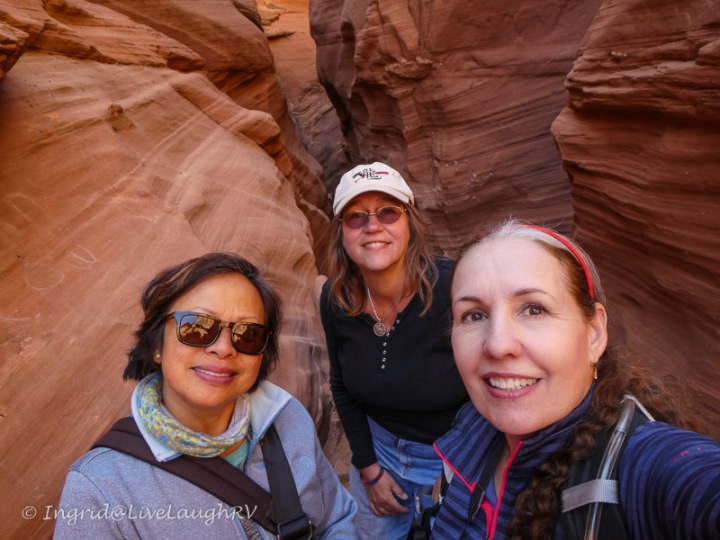
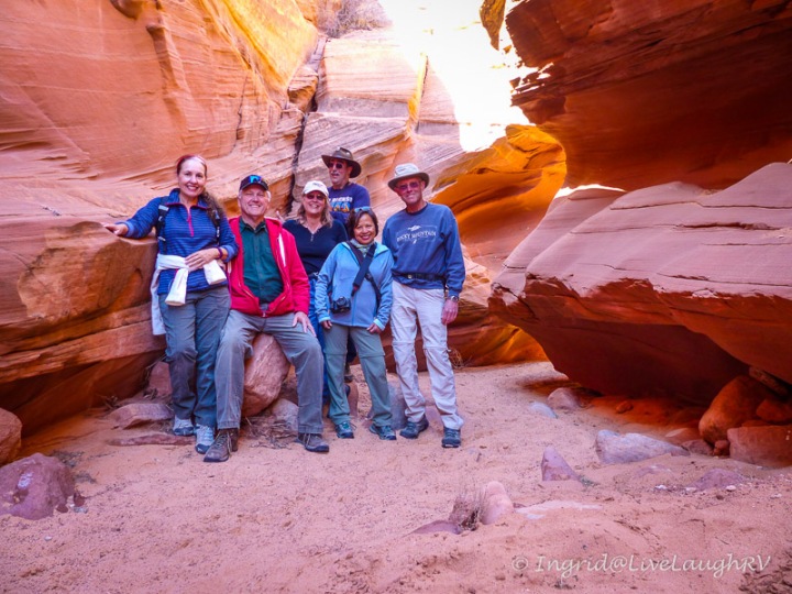
Over the past few years, the three of us have crossed paths rather happenstance. I’ve bumped into these ladies separately in Texas, Arizona, Colorado, and even Idaho.

The three of us have serendipitously found ourselves camped in Texas and Arizona while Faye and Mona Liza have stumbled upon each other in Utah and Canada.

This past winter, Faye and I spent a month camped at the same RV park in Phoenix, Arizona, but it had been quite a while since either one of us had seen Mona Liza. Thus, a little planning was in order. Since Mona Liza and Steve had a well-planned RV travel itinerary scheduled with firm reservations, Faye and I did a little rearranging of our own schedules so the three of us could meet up.

After comparing notes, it was decided Page, Arizona, would be the best place for us to connect even though we’d have less than 48 hours to hang out together. With that said, we didn’t waste any time. During our first happy hour, we discussed potential hikes for the following day.

We all love hiking slot canyons and our first consideration was the Wire Pass Trail, but that would require at least an hour’s drive north into Utah and the group didn’t want to waste our short time together driving. Plus, Mona Liza and Steve would be heading out of town and traveling the next day anyway.

hiking near Page, Arizona
Our group – me center front, Mona Liza on the left, my husband Al in the red, then Faye, Steve, and Dave

Unanimous decision

After a short discussion over drinks, we agreed on Water Holes Canyon for the hike of the day. Since this self-guided slot canyon trail is located on Navajo land, a permit is required. Obtaining the permits turned into a little laughable fiasco since much of the info we found online seemed to be outdated.

As of this writing, we purchased the permits to hike Waterholes Canyon at the  Lake Powell Navajo Tribal Park Office located on Coppermine Road, 3 miles south of Page and next to the LeChee Chapter House. We paid $12 per person and the office is closed on weekends.

Note: The state of Arizona does not participate in daylight savings time. We never change our clocks. BUT the Navajo Nation does. Depending on the time of year you visit, you’ll want to verify the time so you arrive at the appropriate hour for any Navajo Nation tour.  UPDATE – As of May 2018 access to the Waterholes Canyon trail is limited. Permits are no longer being issued and a guide is required. The information regarding this trail is ever-changing and confusing. Please do your homework for the latest information before embarking on any hike on Navajo land.

the trail from the parking lot to the canyon

With permits in hand, we hit the trail around 9:00 a.m. (Arizona time). The trail is clearly marked with rocks leading from the tiny parking area down into the canyon. Once we navigated the steep descent into the canyon, we took a left heading east.

The trail also goes to the right, but once you pass under the highway bridge, you’ll need some serious Canyoneering skills…. as in ropes, ladders, strong upper body strength, rappelling, and experience – I think you get the picture. So take my advice and go left, east of the highway.

Once you pass under the Hwy 89 bridge, the trail is for experienced hikers with canyoneering skills.

The trail starts out wide and sandy. Our group oohs and ahs at the unique red sculpted sandstone. It was a beautiful morning with few other people on the trail …  just yet.

Eventually, the canyon starts to narrow … hence the term slot canyon. More oohs and ahs were heard!

As the trail narrowed, there were a few obstacles for those of us a tad more vertically challenged. But we all excelled in our team-building efforts.

The most challenging part of the entire hike for me was that first ladder because it wasn’t quite tall enough for my comfort level. Thank goodness I had help at the top. Mona Liza needed help being pulled up as well.  The two ladders strapped together made for a rickety setup and we all took caution climbing it.

Once past the ladder, the slot canyon continued to wow us with its beauty. With three out of the six of us carrying cameras, there was plenty of stopping. With all the stopping to admire the canyon and snap photos, there was no cardio workout for this group.

Dave and I compare camera settings

Photographing a slot canyon can be a challenge due to the light, but that’s also what makes it so interesting. I’ve heard great things about the Native guides at Antelope Canyon instructing photographers on the best camera settings. Dave said he learned a  lot about his camera and the best settings from his guide when they hiked Upper and Lower Antelope Canyon a couple of years ago. Hmm, I may need to take one of those tours yet.

Depending on the time of day you visit, the colors of the rocks can vary greatly. So I highly recommend taking the time to admire the ever-changing light.

A word of caution …. Be sure to check the weather before embarking on any slot canyon hike. Remember how a slot is formed …. rushing water. You’ll want to avoid a flash flood, which can occur even if the rain is many miles away and upstream. This is not something to be taken lightly and even experienced hikers have lost their battle with a canyon flash flooding.

Once we reached the end of the trail (near the overhead power lines), it was time for us to turn around and view the canyon from a new direction. The hike is just as amazing on the return, but this is also when we started running into crowds. Seems as the day progresses, it can get busy.

Time to climb back out of the canyon. We need to join Al up there!

The climb back out of the canyon is a bit steep and this was another area where I was glad I wore good hiking shoes for traction. In the above photo, the hike up is around that bend and up to where Al is standing. Seems I failed to photograph the trail back up 😏

But here’s one of Dave’s photos showing us hiking down, and showcasing the kind of rock we had to walk on. This could get really slick if wet. As it was, the rock is dusted with sand and gets a little slippery in spots.

slot canyon
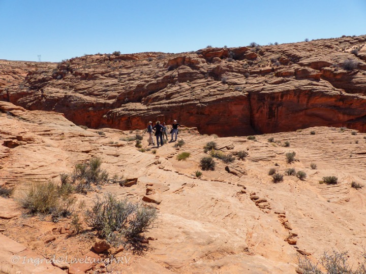
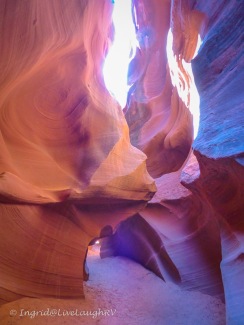
Waterholes Canyon is about a 3-mile (total) out-and-back hike. I loved it! It was so much fun …. partly due to the stunning scenery but a bigger part due to the wonderful camaraderie.

Yep, this was one great hike … a great hike with great friends. Doesn’t get much better!

I’m so glad we rearranged our travels so we could all connect for this fantastic hike. Unfortunately, as full-time RVers, it’ll be a while before we bump into each other again. Seems we’re all heading in different directions this year.

Laughter and adventure near Lake Powell – Thanks for the memories!

slot canyons
Hiking a slot canyon with friends

Good humor is a tonic for mind and body. It is the best antidote for anxiety and depression. It is a business asset. It attracts and keeps friends. It lightens human burdens. It is the direct route to serenity and contentment. – Grenville Kleiser

As of May 2018, access to the Waterholes Canyon trail is limited. Permits are no longer being issued and a guide is required. The information regarding this trail is ever-changing and confusing. Please do your homework for the latest information before embarking on any hike on Navajo land.

Take a Hike in New Mexico

Some places resonate with me more than others. I’m not always sure why or what the deciding factor might be, but when I stumble upon a unique landscape that gives me goosebumps, I know I’m someplace special.

Kasha Katuwe

Between all the social media platforms, there’s no shortage of finding exciting travel inspiration. The moment I saw a photograph of these cone-shaped tent rock formations, I knew I had to see this place with my own eyes.

National Monuments

35 miles south of Santa Fe, New Mexico, is a complex and unique geological landscape called Kasha-Katuwe Tent Rocks National Monument. This relatively new monument was designated as such in 2001.

The sculpted cliffs and peaked hoodoos were formed from volcanic eruptions that occurred more than six million years ago.

There is a somewhat uniform layering of volcanic material causing bands of white, grey, beige, and pink colored rock.  It’s a fascinating and perplexing sight.

Over time, wind and water sculpt these rocks creating canyons, scooping holes, and contouring hoodoos. Mother Nature’s artistic and creative hand had me awed and smiling during the entire two-plus hour hike.  I found myself hiking this fun trail several times during our two-week stay in the Santa Fe area.

Kasha Katuwe Tent Rocks National Monument

Without further adieu, let’s take a hike…..

Getting there: As we approached the fee booth station, we were greeted by a ranger. There’s a $5.00 daily fee (as of Aug 2016) or free with your Annual National Park Pass.  From the fee station, we continued for five miles down a paved road that crosses private property owned by the Pueblo de Cochiti.

Kasha Katuwe Tent Rocks National Monument

We are asked to respect the traditions and privacy of the local Indians, and thus, no stopping along the way, no photography/video, and no drawing/painting.  Also, no commercial photography within the park is allowed without a permit.

Once we neared the trailhead, there were three different gravel parking lots that can accommodate just about any size vehicle (including RV’s).  There’s a couple of vault toilets, but no water….. so be sure and bring plenty of drinking water.  You’ll need it.

Awed beyond words!
Awed beyond words!

Unlike most national parks and monuments, there are no scenic overlooks near a parking lot around here. The only way to view the tent rocks and observe this stunning landscape is by foot; hiking via a dirt, sometimes sandy trail.  And by the way, no dogs are allowed anywhere. You won’t even be allowed through the fee station with a dog in your vehicle.

Kasha-Katuwe

The 1.2 mile Cave Loop Trail is rated easy and partly handicap accessible.  There are some unique rock formations and a hand dug cave along this trail, but the real gem of the park is the Slot Canyon Trail …… definitely not to be missed.

Kasha-Katuwe Cave Trail
Kasha-Katuwe Tent Rocks National Monument

The Slot Canyon Trail is a 3 mile (total) out and back hike with a 630-foot elevation gain and connects with the Cave Loop Trail.

We hiked the combination of both trails making for a wonderful 4.2-mile hike. For my level of hiking ability, this trail offered me the perfect amount of challenge and visual stimulation.

Cave Loop Trail as we hike toward the Slot Canyon trail
the beginning of the Slot Canyon Trail

Although from Al’s point of view, there may have been way too much visual stimulation (if there is such a thing) which resulted in an excessive amount of photo-op stops, much to his chagrin.  Perhaps that’s why my subsequent hiking visits to Kasha-Katuwe were tackled as a solo hiker 😁

The moment we connected with the Slot Canyon Trail, the cliff walls rose on both sides and I felt like I had entered a secret garden of sorts. I believe, oh my gosh, was uttered by me around every bend.   As the canyon walls continued to narrow, we were greeted with obstacles along the trail.

Slot canyon hiking

Nothing we couldn’t handle … however, those that are vertically challenged or suffer from short leg syndrome, like moi, may find themselves stretching out those leg muscles just a tad.

Easy peasy!
Easy peasy!

In some spots, the slot canyon became very narrow, so narrow that there was only room for one foot at a time.

one foot at a time!
one foot at a time!
one hiker at a time!
How cool is this?
How cool is this?
Fits like a glove!
Fits like a glove!
Loved it!
Awesome!

Once we exited the slot canyon, we were welcomed by those teepee shaped hoodoos …. each uniquely sculpted by the elements and each equally as impressive.

Kasha-Katuwe Tent Rocks National Monument
cairns
hiking

It didn’t take long and we could feel the trail climbing and instead of looking up at the amazing tent rocks, we were now looking down upon them.

Kasha-Katuwe Tent Rocks National Monument

We continued up the trail and stopped frequently to look back.

New Mexico hiking
this was the most challenging spot for me on the entire hike
Kasha-Katuwe Tent Rocks National Monument

As we reached the top of the trail, we had temporarily hiked away from the tent rocks. The trail continued out onto a narrow mesa which provided a bird’s eye view of Kasha-Katuwe Tent Rocks National Monument.

trail - drop offs on both sides. Birds eye view in all directions. The lake in the background is where we camped to be near Kasha-Katuwe; Cochiti Lake
The trail drops off on both sides. Bird’s eye view in all directions. The lake in the background is where we camped to be as near as possible to Kasha-Katuwe; Cochiti Lake Campground

And of course, a few more “Oh…. my…. gosh’es were uttered as I stood on the edge gazing down.

Standing on the edge gazing in awe!
Sitting on the edge as I admire the view below - hey look, there's the trail
Sitting on the edge as I admire the view below – hey look, there’s the trail
We can see hikers on the trail. Since this is a out and back hike, we'll be down there shortly!
We can see hikers on the trail. Since this is an out and back hike, we’ll be down there shortly!
Heading back down the trail.
Easy for someone 6'3".... entertaining watching the 5'4" short legged gal
Easy for someone 6’3″…. entertaining watching the 5’5″ short-legged gal
I steady myself
I steady myself
Not an obstacle I couldn't handle on my own!
Not an obstacle I couldn’t handle on my own!
This is where being short works in my favor ;-)
This is where being short works in my favor 😉

The return hike to the trailhead was every bit as amazing as it was at the beginning.

We returned back to the trailhead via the Cave Loop Trail

The Pueblo de Cochiti people view Kasha-Katuwe Tent Rocks as a very special place and justifiably so.  After Al and I made this first hike, I returned three more times to tackle this perfect (in my book) hike.  Perfect – even when considering all the obstacles one might bump into.

Oh no, someone wasn't paying attention!
Oh no, someone wasn’t paying attention! At least I managed to stop the blood from running down my leg.  I did attract a little attention from fellow hikers…. You know, those “Are you ok?” looks and comments.

One morning, I hit the trail at 8:15 and encountered only one couple on the trail for that first hour.  It was awesome having this amazing place to myself and hiking in solitude.  All of my senses were alert.

Kasha-Katuwe

The visual delight of the sun peeking from behind a rock was a reminder of a new day unfolding. I listened to the light sound of a lizard moving, and the loud squawking of birds soaring overhead.  I breathed in the crisp clean air scented of pine. There was the random sound of tiny rocks tumbling, acting as a reminder that this land is in a constant state of change.

Kasha-Katuwe

There was the occasional touch of admiration and respect for this special and sacred place.

sitting on the edge!
My church!
My church!
Kasha-Katuwe

Yes indeed, some places touch my soul more than others and Kasha-Katuwe touched mine more than I ever expected.  I sure hope to return someday!