What a difference a year makes!

Last week hubby and I completed one of the best hikes we’ve ever done.  The scenery was great, the weather cooperated, and we both felt strong and prepared for it.  We knew the Peralta Trail would be our most ambitious hike to date but after a couple of weeks conditioning on the trails near Lost Dutchman State Park we felt ready.Superstition Wilderness trails

hiking Superstitions
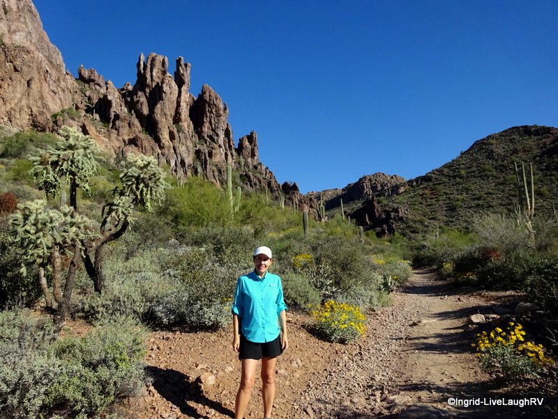
On a personal note; what made this hike even more special and rewarding was the fact that a year ago I had difficulties walking a Walmart let alone a rugged trail.

The first half of 2014 had me struggling with some health issues and I wasn’t sure I’d ever be able to hike a trail like this. I won’t bore you with my medical woes…even I don’t want to hear it about it LOL.

Suffice it to say; WOW, what a difference a year makes.  I feel great and can’t believe I managed this hike without issue!

Peralta  Trail
Five minutes into the hike we began the climb. I had to stop and admire this part of the trail. All I could think about was what a fabulous counter top this rock would make. Yep, that had hubby rolling his eyes too!

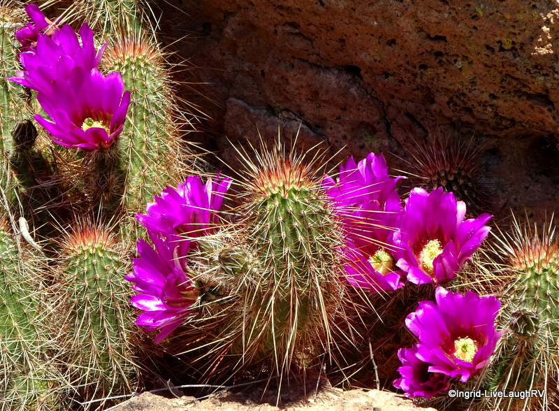
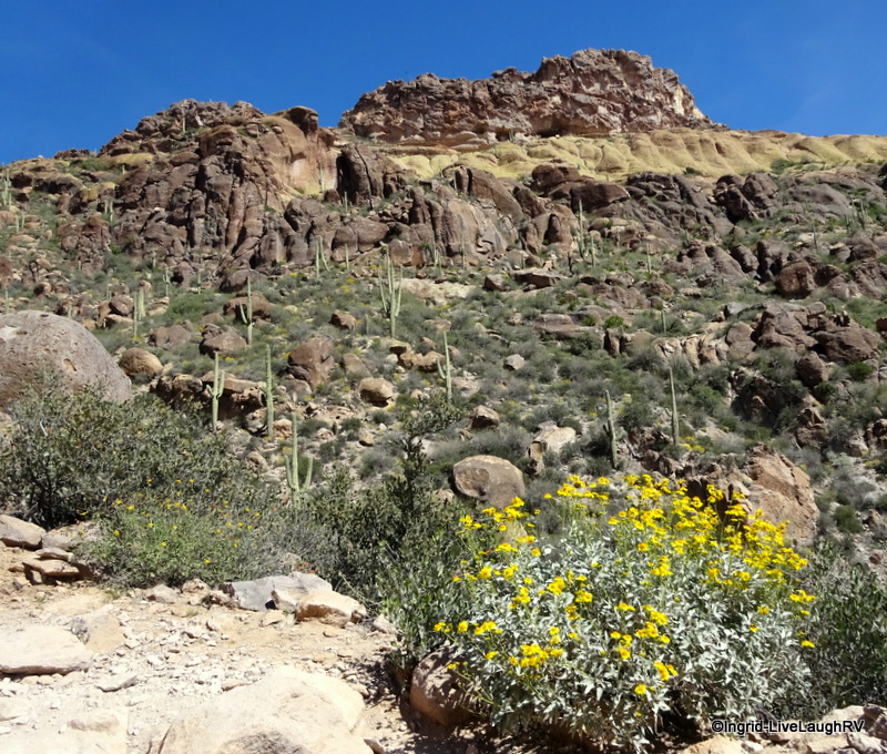
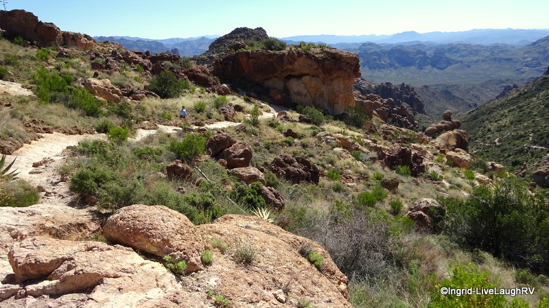
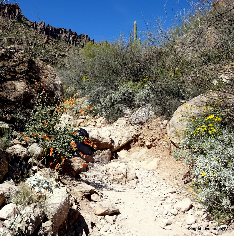
This amazing hike begins at the mouth of Peralta Canyon and climbs steadily through a varied terrain.  The area is stunning and has a complex volcanic origin. The rugged trail starts amongst oak and mesquite scrub then eventually changes to cacti and rock.Peralta TrailAlthough the trail is rated moderate – strenuous, that doesn’t stop hikers from making it one of the most heavily used trails in Arizona.  Most folks take the trail up 2.2 miles (1,380 foot uphill trek) to the crest at the Fremont Saddle to enjoy a dramatic view of Weavers Needle then retrace their steps back down to the trailhead.  That’s exactly what Al and I did.

Peralta Trail Superstitions
This diagram shows the elevation gain from the trailhead to the saddle

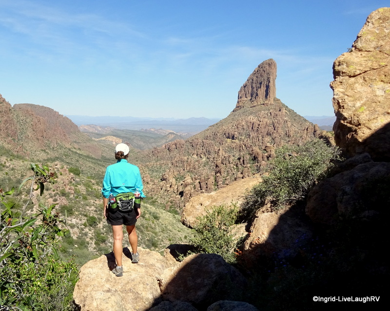
Al and I took a 20 minute break at the Fremont Saddle to have a snack while admiring the view of Weavers Needle.Weavers NeedleWeavers NeedleFlowering Cactus
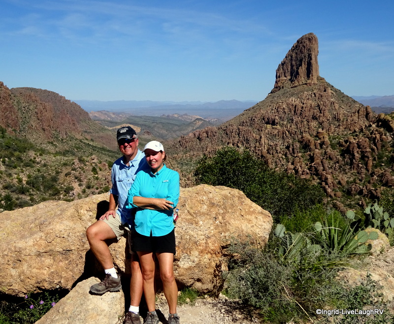
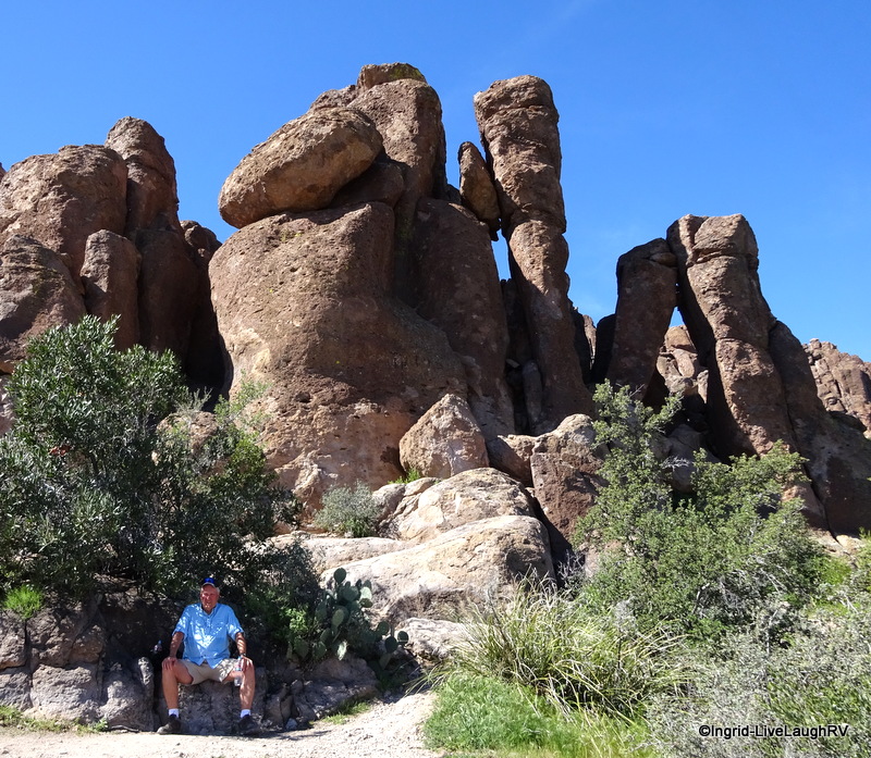
There’s a stark rugged beauty to the Superstition Wilderness Area that has a draw about it, not to mention all the rumors concerning lost gold mines and secret maps.

This is harsh inhospitable terrain to those not equipped to meet natures own terms.

As a matter of fact, the Superstition Wilderness Area keeps Search and Rescue busier than they’d care to be.  The stories are endless of those who have either disappeared, required rescuing, or have actually perished.  The land is unforgiving.

Superstition Wilderness AreaAl and I came prepared with plenty of water and a snack and although we were tempted to hike out to the “lone pine tree” for an even more spectacular view, we knew that would add about another half hour to our hike, but more importantly might require more water than we were carrying. Not worth chancing.

We promised each other the next time we hike Peralta Trail, we’ll hike to the lone pine.

Peralta Trail
Next time we’ll hike over to that lone pine tree

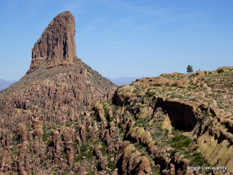
Weavers Needle is a dramatic volcanic plug that rises 4,443 feet.  It’s surrounded by hoodoos in all directions adding a sense of unique drama to the already stunning landscape.  The photos just don’t do it justice.

As we marveled at incredible views in all directions, we took our time enjoying this fabulous hike. It took us about 3 1/2 hours to complete…. 3 hours of hiking with a 1/2 hour of stopping.  After all, I needed photos for proof I completed this hike… more so for me, than for you!

hiking Superstitions
Al finds some shade and patiently waits for me to take photos

We tackled this hike on a Sunday in March (Spring Break) and although this is considered an extremely popular trail especially on weekends, we thought the trails at the State Park seemed much busier.  That said, we were off the trail by noon.  So maybe it got busier as the day progressed.  Personally, we wouldn’t hesitate hiking it again on a weekend.

Peralta Trail
Hubby as we head back down Peralta Trail
hiking the Superstitions
Al on the trail gives perspective to the vastness of the terrain and if you look to the very right center edge on the photo you can see the trail meandering down

We can’t wait until we’re back in the area in the fall to tackle this trail again…. it’s a butt burner 🙂

Peralta Trail Superstitions
The trail is lined with flowers in spots. The desert in spring is a treat to behold.

If you’re interested in visiting Weavers Needle but looking for a trail less popular, check out LuAnn’s post over at Paint Your Landscape.

Location of the Peralta trailhead:  located off US Highway 60 east of Phoenix, Arizona.  At the traffic light in the town of Gold Canyon, head north on Peralta Road. There’s a brown directional sign for the trailhead.  The road starts off paved and then the last seven miles are gravel.  The road ends at the trailhead.  There’s a vault toilet but no water.  Leashed doggies ok.

Superstition Wilderness Trails West: Hikes, Horse Rides, and History
The Legend of the Lost Dutchman’s Gold Mine

Justified Paranoia

After enjoying yet another gorgeous evening at Lake Pleasant, we hit the road last Sunday morning. Usually I’m excited on travel days because it means we’re off for new adventures, but last Sunday I was engulfed with a sense of paranoia. A feeling of what will go wrong this time.

RVing
Our last evening at Lake Pleasant

Once the wheels started rolling, I settled in and calmed down. However, several times I did ask Al, “Did you hear that?” or “Do you smell that?”  “Stop worrying, Ingrid”.

A little over an hour later, we pulled into our friend’s place in Apache Junction. Our travel day took us from the far northwest side of the Phoenix valley to the far southeast side of the valley in the town of Apache Junction.

Apache JunctionApache Junction is a favorite location amongst RVer’s.   There are more RV Parks than one can count as well as the ever popular Lost Dutchman State Park and Usery Regional Park can be found here.

And with the picturesque Superstition Mountain ever present in the background, what’s not to like about this area?

We find our friend’s place with ease and are met with open arms. They own a place with a double lot and the second lot has full hook-ups for us.  Yippee!  While Cheryl and I hug hello, with pointed finger John engages Al in a “what happened there?” discussion. Remember …. a week ago we had new waste lever valves installed?  That required pulling down the thermopan (belly cover).  Well, the reinstallation didn’t hold up thus the thermopan was dragging on the ground ….. grrr!  Looks like our stay with friends won’t be all socializing; it will also entail some repair work.

Superstition Mountain

However, we did manage to introduce John and Cheryl to the Organ Stop Pizza.  This is one of those must see places during any visit to Phoenix, Arizona.  It’s a one of a kind experience and the food is good as well.  Definitely worth a visit at least once.

And then I can’t forget to mention the lovely evening we managed to squeeze in with friends G & T.  Thanks guys for a great meal and wonderful company.

After a very busy but short stay in Apache Junction, it was time to get those wheels rolling.  In the past, we’ve always taken Interstate 10 toward Tucson then east toward Texas.  This time we wanted to try something different and took two lane Highway 60 east toward the town of Globe.

Apache Indian
Highway 70 near San Carlos Apache Indian Reservation

The raw scenic land continued as we picked up Highway 70 which meanders through the San Carlos Apache Indian Reservation.  The name Geronimo is most definitely associated with this territory.  You can click here for more info about the history or here for the Apache website.  While taking in the sights during our leisurely drive, hubby, the history major, briefed me on the atrocities that occurred around here; not exactly a proud moment for the white man.

New Mexico State Parks
Set up at Rockhound State Park, New Mexico

Finally, we picked up Interstate 10 in the town of Lordsburg, New Mexico.  It wasn’t too long after that, we arrived at our destination:  Rockhound State Park in Deming, New Mexico.  And although I do feel justified in feeling paranoid about something going wrong with the truck or the RV, I’m pleased to say after a 4 1/2 hour drive we made it to Deming without incident.  Knock on wood Murphy has been left behind.

FYI…. my studly MacGyver did a great job fixing the thermopan.  I don’t know what I’d do without him 😉  New Mexico

The John Wayne Signature Collection (Stagecoach / The Searchers / Rio Bravo / The Cowboys)
Moon New Mexico (Moon Handbooks)


Beautiful Day…

It’s going to be a beautiful day.  Bear and I are on our morning walk, and yes it’s about 6:30 a.m.  Same time every morning.  That boys internal clock never fails.  The sun is still behind the Superstition Mountain.  There’s a lovely coating of snow near the “Flat Iron”.  Bear and I enjoy a nice, leisurely walk this morning.  Yesterdays walks were way to short leaving Bear well rested and full of energy.

"Flat Iron" - Superstition Mtn

Over coffee, Al and I decide whether or not to join the group on a hike.  We decide to opt out.  Early on in our trip, at different times, Al and I both incurred minor injuries.  Thus, curtailing our hiking abilities.  Not wanting to embarrass ourselves or hold the group back, we make our own plans for the day.  I’m super excited to take some photos of the rare coating of snow in the distance.  Al and I decide to take a quick drive to Canyon Lake and have lunch in Tortilla Flat.

We head out for our drive shortly after breakfast and find some scenic stops along the way….stops we did not make on our previous trip to Canyon Lake.  It’s a gorgeous day…amazing blue sky, light breeze, upper 60’s…can’t get much better!  We take our time and enjoy the scenery and the day.

Canyon Lake

There’s definitely more traffic today than there was a week ago when we took this same drive.  We assume it’s because the weather was so nasty over the weekend.

Dollar bills decorate the walls

We get to the little town of Tortilla Flat, population 6, just in time for lunch.  This “little” town resembles a long ago western town.  The restaurant is already bustling with activity.  We’re seated at a table to the rear.  The walls are plastered with dollar bills.  The bar stools are saddles.  It’s a fun little place and the burgers are very tasty.  They’re grilled over an open flame outside.  Service was quick.  Al enjoys a light Beer on tap brewed specifically for this restaurant at a local brewery in Phoenix.  I visit the restroom before leaving…..darn, wish I had my camera in here….way too funny.  Amusing paint job on the stall doors.  You’ll just have to visit and see for yourself!

Tortilla Flat

After lunch, we step into the gift shop and look around.  We head over to the ice cream shop.  We had heard they have fantastic ice cream.  I try to avoid dairy and opt to try the fudge while Al enjoys the ice cream.  Yes indeed, Al attests the ice cream is very good.  As for my fudge…yum…Mackinac Island, you have some serious competition.  We walk around a bit more and allow the sun to warm us and our food to digest before heading home.

Gitty up...

If you’re in the Phoenix area, I highly recommend a visit to Tortilla Flat for a relaxing and scenic day. The most enjoyable part is the drive getting there…very pretty.  If the weather were warmer, we might even consider renting a watercraft of some sort on Canyon Lake.  The Marina offers a variety of boats to rent including wave runners. 🙂  We return to our Rig and take Bear on a nice long walk around the campground.  Lost Dutchman State Park is one of my favorite places and not just on this trip.  We look forward to returning.

Lost Dutchman State Park

The group has returned from their morning hike and interested individuals are invited to try out WII Fit at one of the couples RV’s.  Fun… Al and I decide we MUST get one.  Entertaining and good for us.  So after we all play around, the group heads out to the Organ Stop Pizza.  Al and I have been there a couple of times before and are still immensely entertained.  The food is pretty good too.  I highly recommend this place, even if you’re not a big pizza eater.  In addition to pizza, they offer a salad bar and some Italian dishes.  This is home to the largest Wurlitzer Organ in the world and even if you’re not a fan of the Organ (that would include me) you need to see this place at least once and experience it for yourself.  It can’t really be described.  The Organ Stop Pizza is located in Mesa just off US-60        OrganStopPizza.com         A must see when your in the Phoenix area !

10 mph….

How is it we’ve driven over six hours today and still have over a half a tank of gas?  Trust me, it’s not the gas mileage! It’s six thirty in the morning and Bear starts to pace back and forth.  “Come on mom.  I gotta go.”  Al’s still sleeping.  I roll out of bed gently, trying not to wake him.  I throw on the clothes from yesterday and put on my sweatshirt.  Off we go for a brisk morning walk.  The sun isn’t up just yet and the Superstition Mountain takes on new shades of color.  The colors seem to change with the movement of the sun.  What a sight to behold.Lost Dutchman My neck is a little stiff this morning.  I had a somewhat restless night for some reason and am not in the mood for an all day activity.  When Bear and I return to the Rig, Al is up and has started the coffee.  Ummmm, love my coffee……oh, and Al too.  Al would like to check out Roosevelt Lake today.  There’s three ways to get there from Lost Dutchman State Park.  Al has it all planned out. *****************************************************************************************************

Roosevelt Lake
Theodore Roosevelt Lake

Al’s plan is to head north to Highway 87 toward Payson.  Catch Highway 188 south.  Hwy 188 runs all along Roosevelt Lake, allowing us to check out the campgrounds and any boondocking possibilities.  We’ll continue south on Hwy 188 until it ends at US 60.  We catch Hwy 88 and return to our camp at Lost Dutchman.  On this route, the roads are paved and access is not an issue or a challenge.  But oh no, Ingrid can’t just agree and go with Al’s plan………… *****************************************************************************************************  Hubby’s plan would be an all day trek and we would take a cooler with food and drinks.  I’m just not feeling up to the whole day thing and suggest we just go to Canyon Lake and Tortilla Flat and then return home.  This would be a short morning excursion.  Al, always the gentleman, acquiesces.  We forego the cooler.  Take a couple of bottles of water for us and big jug for the dog.  Since we’ll be back for lunch, we forego taking snacks/food.  (yeah, dumb move, I know…one should always carry at least a power bar, etc.)

Canyon Lake
Canyon Lake

Canyon Lake is approximately fifteen miles or so up Highway 88 from Lost Dutchman State Park.  The drive is very scenic.  I drive, which allows me to pull over anytime I see a potential photo-op.  I’ve been known to be rather spontaneous when I wish to stop, and although Al has tried very diligently to pull over and accommodate my whims when I yell “stop”…..well, let’s just say, it works best when I’m behind the wheel when I’m struck with a whim.  You know, martial bliss and all 😉

Apache Lake
Apache Lake

Canyon Lake is beautiful.  The sky is an amazing blue.  We stop here, click, click.  We stop there, more clicks.  So it’s on to Tortilla Flat.  This is a “little” western town, population six.  There’s a restaurant, ice cream shop, gift shop and post office.  It’s barely 9:30 in the morning and things aren’t open just yet.  Al and I decide to drive a bit further….maybe to Apache Lake.

Apache Lake
Hwy 88 northeast of Apache Lake

Tortilla FlatAh, this is when our drive gets interesting.  The pavement ends.  Remember when I said that there’s three ways to get to Roosevelt Lake.  From Payson to the north of the Lake head south on Hwy 188 or from Globe, head north on Hwy 188.  The third and most challenging route and NOT recommended by most is to continue on Hwy 88 from Tortilla Flat to Roosevelt Lake.  Guess which route we’re taking?   Another 5-10 minutes, not so bad.  We’ve been on much worse.  Oops, should not have said that.  Here comes the wash board, rocks and holes.  Two lanes wide goes down to one and a half wide then down to one lane.  We climb in elevation.  The lane and a half dirt road is cut into the side of the rock and earth.  There’s no room for error.  Some crazy sh*t is pulling a boat!

Fish Creek Pass
Crazy guy pulls boat! Fish Creek Pass

Fish creek pass turns out to be the most challenging of the entire drive.  There’s a thousand foot change in elevation as we go up and then back down.  The switch backs are tight, quite often single lane.  If two vehicles meet, one needs to back up so the other can squeeze by.  This occurred numerous times.  What happened to that “easy” trek I recommended?

Hwy 88
They call this road a scenic highway? Fish Creek Pass….Hwy 88

We get to Apache Lake and find a restaurant with an outdoor patio.  It’s 11:30 and we’re hungry.  I order a BLT and share my bacon with Bear.  The waiter also brings Bear a large bowl of water.  I believe an extra nice tip is in order!

Apache Lake
Bear goes out to lunch

Apache LakeWith our internal organs readjusted, after the jolting from the rough ride, and tummies full, we’re off to Roosevelt Lake.  There is no way in heck we are driving back the way we came.  As we continue on our journey, the road widens but the washboard is the worst.  Every time I try to accelerate and go a bit faster, we get jolted so badly the rear of the truck starts to fish tail.  I’m sure the extra long wheel base on our extended bed truck is not helping.  Perhaps a Jeep would be more appropriate.Tonto National Forest Finally, we make it to Roosevelt Lake.  We check out some campgrounds and find boondocking at the waters edge….perfect.  We make notes for next winters excursion.  This is part of the Tonto National Forest and thus the cost of overnight parking should be $3-$6. We’re traveling on Highway 188 along Roosevelt Lake.  The road is wide, ah, the road is paved, double ah.  The speed limit is 55.  I’m driving at 45 …..it feels fast.  I bring’er up to 55….wow, now I’m going super fast.  I routinely check the speedometer to assure myself I’m not speeding (I would never do that…yeah, right!….who said that?)  After hours of travel at approximately 10 mph, 55 feels like 85. We continue south on Highway 188 until it intersects with US 60.  We switch drivers.  I’m all photoed out and exhausted.  “Beam me up, Scottie”.  Oh, how nice that would be at this moment.  US 60 still provides scenic vistas and by the time we drive past the Boyce Thompson Arboretum, I am somewhat recovered from the arduous drive and am tempted to have Al stop for a photo-op.  Nah, it’s been a long day.  I’ll make a note for next years visit.

Superstition Mountain
A very tired boy –

  We left at 8:30 this morning and returned shortly after 4:00 this afternoon.  Upon our return, we each down a bunch of water.  Bear eats his dinner, gets a quick walk, then crashes into a deep sleep.  I’ll grab a bite to eat then head off to the shower.  The same dirt that turned our shiny blue truck into a dull tan color has left a similar layer of dust and dirt on me. Al and I are clean but exhausted.  Over a glass of wine we discuss the events of the day.  We agree it was a fun, exhilarating adventure and we would do it again in a heart beat……..in a Jeep that is!Fish Creek Pass