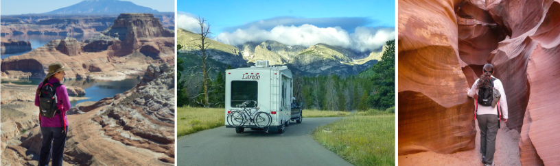
Are you an adventurous traveler? Are you looking for a scenic memorable drive? Well, I’ve got just the day trip for you. Al and I first drove this 80 mile scenic loop three years ago and it still ranks as one of our favorite day excursions.
On the far southeast side of the greater Phoenix area lies Arizona’s oldest highway. This former stagecoach trail which runs through the Superstition Mountains was  originally used by the Apache Indians thus aptly named The Apache Trail.
The Apache Trail is officially known as State Route 88 and links the town of Apache Junction with Theodore Roosevelt Lake. The trail was developed into more of a road in the 1930’s to support the development of dam’s along the Salt River creating some beautiful lakes in the process.
There’s a bunch of interesting sights and views along the way which necessitate lots of stopping. Photo-op anyone? Thus, the Apache Trail Circle Loop requires an entire day for the excursion. It’s also not for the faint of heart, which I’ll explain in a minute.
We’ll start our journey from the town of Apache Junction and head north on State Road 88, aka The Apache Trail. Our first stop is the Superstition Mountain Museum.
The museum collects, preserves, and displays the artifacts, history, and folklore of the Superstition Mountains. Even though we knew we had a long day in front of us, this picturesque place is worthy of a photo-op and stroll around the historic buildings. We’ll tour the museum another day.
Moving on; our next stop is the Goldfield Ghost Town. Goldfield was once a happening gold mining town back in the 1890’s. I found myself on more than one occasion visiting this little tourist attraction. There’s free parking and free strolling around, but there is a fee for each attraction. You can click on this link for more info on attractions. We don’t usually do the ‘tourist’ thing so I can’t vouch for any of the paid attractions.
The quaint little shops offer unique trinkets as well as the usual tourist stuff. The grounds are loaded with original mining equipment. It’s obvious these are the original buildings and have been standing for a very long time. As a matter of fact, a museum building was closed while construction workers were busy shoring up a second floor balcony.
As I strolled around Goldfield Ghost Town, I could almost visualize the harsh realities of life over 100 years ago. These were hardy folks living in an unforgiving and harsh environment. I also found it funny that the Bordello was located near the church.


For those unable to secure a campsite at the Lost Dutchman State Park, Goldfield Ghost Town does have a campground. It’s a bit rough, but at least it’s a place to park in a pinch.
 And speaking of Lost Dutchman State Park, which is just a little further up the road; we discovered some of the best hiking trails at this park. We take full advantage of these trails anytime we’re in the area. There is a day use fee unless you are already camped in the park. Lost Dutchman State Park requires it’s own day to explore and it’s own blog post. And I highly recommend camping here.
Continuing on our journey the road starts to climb, twist, and bend. Shortly after passing the state park we enter the Tonto National Forest. The scenery becomes more rugged and stunning with each mile. March is particularly beautiful as the road is lined on both sides with yellow blooms from the brittle bush and desert marigolds.
Twenty miles north of the town of Apache Junction, we round a bend and are graced with the sight of an oasis in the desert. Canyon Lake with it’s deep blue waters surrounded by rugged cliffs and rocky terrain is a pleasant and unexpected surprise. Definitely worth a few photo-ops around here. Canyon Lake in itself is a great day excursion; perfect for a picnic, kayak adventure, or even a cruise aboard the Dolly Steamboat.
 A few more miles up the road is the cute little town of Tortilla Flat – population 6. This is the perfect place to stop for lunch. The restaurant serves up great burgers and has a fun décor.
We recently revisited with friends and in the photo you can see dollar bills stapled to the walls along with old mining tools and historical photos. The bar stools are saddles and the little general store serves up some of the best ice cream and fudge around.
With tummies full, it’s time to brace ourselves for the truly adventurous part of the drive. Just past the town of Tortilla Flat the pavement ends. Most rental car companies will not want you driving this road and it’s not recommended for any vehicle over 25 feet in length…. Definitely no RV’s!
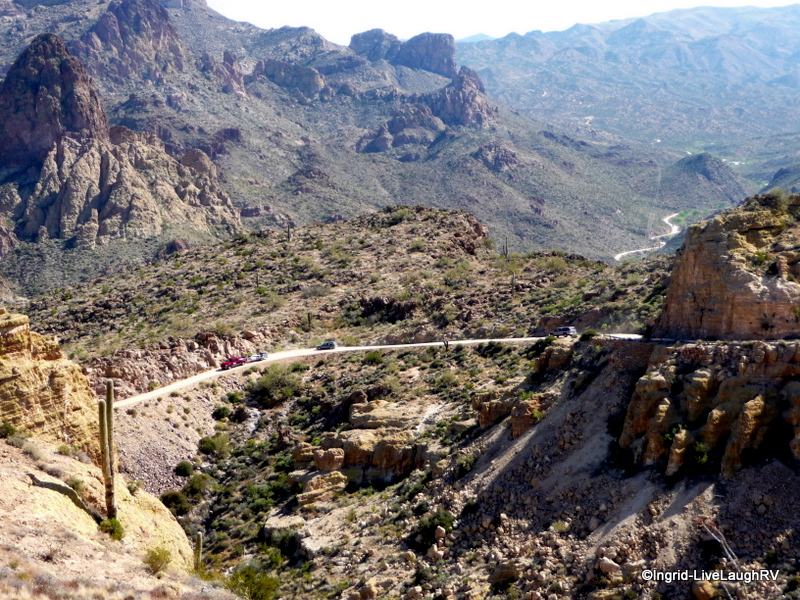
 The gravel road is wide and in pretty good condition up to the scenic view parking lot. Obviously the vista is worth a view and for those less adventurous this would be a good place to turn around and retrace your journey home.
For us? Al and I are used to driving unpaved mountain back roads with steep cliff drop-offs with no safety barriers or guardrails. In other words, the stretch of road between Tortilla Flat and the Roosevelt Dam is not for the faint of heart.
As we continue past the scenic overlook the road narrows and winds. This two way traffic road narrows down to about a one to one and a half lane wide road. Those going down hill supposedly have the right of way and it’s not uncommon for the need for someone to back up to a wider spot in the road so vehicles can pass by each other. Fish Creek Hill/Pass is the worst part of the journey with sheer drop offs, very narrow, lots of turns, and a steep elevation change. One lane bridges and a washboard gravel road add to the overall adventure. Once we reach Apache Lake, another beauty, the road becomes a little easier to traverse. Due to the washboard condition of the road and our extra long wheel base on the F-250, it’s slow going. Two and a half hours after leaving Tortilla Flat we finally arrive at the Theodore Roosevelt Damn and Lake.


We tour the campgrounds and the boondocking opportunities and are pleasantly surprised. We will definitely be keeping Roosevelt Lake as a possible place to camp in the future. It’s pretty. It’s remote. It’s inexpensive. It’s located within the Tonto National Forest, although the word ‘forest’ is a relative term. You won’t find any of the usual trees around here. This is still the desert.
 The majestic scenery continues from Roosevelt Lake to the active mining towns of Miami and Superior and onto the Boyce Thompson Arboretum.
By this point in the journey, I’m photoed out, tired, and just ready to get home. We make notes for things to see and do in the future.
Whether one is looking for solitude or a host of activities, this part of Arizona seems to offer it all. I remain in awe by it’s raw beauty and fascinated by the plants and animals that survive in this harsh land.
Hmm… whatever shall we do tomorrow?
Wild in Arizona: Photographing Arizona’s Wildflowers, A Guide to When, Where, and How

Arizona Ghost Towns and Mining Camps/a Travel Guide to History


Tried that drive last winter, got turned back by a rock slide. We aren’t taking the Ridgeline next winter so don’t know if we’ll be able to do the drive…unless we can find someone to hitch a ride with 😉
LikeLike
Wow! This place looks really awesome, Ingrid. I love the photo of Apache Lake. Is that a building on top of the rock?
LikeLike
We still haven’t driven the whole trail here. Lovely pics and description of the trip!
Nina
LikeLike
It’s a fun drive and the CRV wouldn’t have any problem, but she will get covered in a thick layer of dust and dirt. Scenery is beautiful 🙂
LikeLike
We drove through there after it snowed on the Superstition Mountains(yeah, I know… SNOW in Phoenix… Didn’t last long). We always enjoy the little drive. There are a couple spots where it can be a little un-nerving for a passenger(or driver), but nothing too serious. I’ve definitely driven worse haha.
LikeLike
We camped at Lost Dutchman SP one year when it snowed and it was beautiful. The Apache Trail does provide some lovely scenery and like you, we’ve driven worse.
LikeLike
Thanks to your recommendation, we made it all the way to Tortilla Flats the last time we were there. We were in a hurry then, but the next time we come back to AZ I sure would like to revisit this place and better still camped at Supersition Mountains.
Do you think our Honda CRV can sustain the 22 miles of gravel road?
LikeLike
The CRV won’t have any trouble and yes you MUST camp at Lost Dutchman SP. It’s too special of a place to pass up.
LikeLike
We did this trail last year! The best “DRIVE” in Arizona! Beautiful pictures, once again my friend!
LikeLike
Thanks Nancy. It is a great drive. I’m now located in your neck of the woods and hitting the outlet mall soon 🙂
LikeLiked by 1 person
I am not in AZ at moment but will be soon!!
LikeLike
One to add to our list of to-do’s. 🙂 Thanks for sharing.
LikeLike
It’s a beautiful area worth checking out in the future 🙂
LikeLike
The unpaved road was closed the day we drove up there. Bit disappointing. We had to attack the views from different directions on different days. Looked like an exhausting but beautiful day trip. Did you go to Boyce Thompson?
LikeLike
One does not need to drive the whole road to enjoy the scenery and experience. Sounds like you still got to see some nice views. We have yet to visit the Arboretum. I hear it’s worth touring.
LikeLiked by 1 person
Excellent job on this post – it is truly lovely. I find that this road is bit rugged for my taste…I guess I am faint of heart. But it sure was fun to meet up with you and to enjoy the trip through your camera.
LikeLike
The road is definitely not for the faint of heart and I find most Midwesterners find it way too scary. Some journeys are best experienced via armchair travel LOL.
LikeLike
Excellent job Ingrid. We truly enjoyed that area also.
Thanks for the tour of the back road. We only did a few miles of the unpaved road and turned around. What gorgeous country it is!
LikeLike
Thanks Marsha. Fish Creek Hill makes the Moki Dugway look like a highway. You would not enjoy. It was a pleasure finally meeting 🙂
LikeLike
Looks like a beautiful trip..and reminds me of the back road to Cripple Creek, CO we took a gazillion years ago…with switchback turns, steep drop offs, gravel and one way..I’m not a huge fan of those roads, but the scenery is spectacular!!
LikeLike
That road and this one have a lot in common although I recall the one in CO to be even worse, but then again I was new to CO. Now I’m a little more used to these roads but still don’t like one lane blind turns with two way traffic…. yikes!
LikeLike
Looks like a great drive. Thanks for sharing this. By the way, as previously mentioned Oatman has a similar restaurant. What fun!
LikeLike
I Googled Oatman. Looks like a fun western town. There’s no loss of unique places to visit in AZ 🙂
LikeLike
Thanks for taking this trip before us so we now have a preview:) This loop is in our plans before we head out of the area. We got a preview yesterday since our hike began across the road from the Canyon Lake Marina. Such a beautiful area!
LikeLike
Just the drive to Canyon Lake in itself is beautiful, but since you have a Jeep you need to do the Apache Trail Loop. It’ll be an all day adventure. Beautiful country. I look forward to your post on the trip and it was great meeting you 🙂
LikeLike
What a spectacular drive and so many fun things to explore! It’s a part of Arizona that we’ve not spent much time in — although we absolutely love Boyce Thompson Arboretum. You mentioned camping at Roosevelt Lake — so I’m assuming you would tow your trailer from the opposite direction? I think I would prefer skipping the scary road between Tortilla Flat and Roosevelt Lake.
LikeLike
Yes, you tow to Roosevelt Lake via Hwy 60 through Globe. You definitely would NOT take Road 88. You and Eric would enjoy staying at the Lost Dutchman SP and exploring the area.
LikeLike
Thank you for the detailed information…it is one of the stop, I’m making with another rider after the Overland Expo in May. Now looking forward to the side trip even more.
LikeLike
Glad I could help. This eastern end of the Phoenix valley is very pretty and worth exploring.
LikeLiked by 1 person
What a beautiful place! Definitely something for us to keep in mind for a possible trip in the future. Love all your great photos, as usual!
LikeLike
I think you would enjoy exploring the area and Lost Dutchman State Park is right up your alley. Hope each day is getting a little easier for you. Time heals 🙂
LikeLiked by 1 person
We love to travel the Apache Trail whenever we are in the area. In another life we pulled a ski boat up and down Fish Creek Hill to ski all the lakes in the area. Looking back, it seems like a rather foolish thing to do. Beautiful country, beautiful photos!
LikeLike
I remember your tale of pulling a boat to Apache Lake more than once. It’s amazing what we did when we were young. It is a beautiful area and we’ve been enjoying our stay very much. We may even spend an entire month here next year. So many trails to explore 🙂
LikeLiked by 1 person
That looks like some great desert kayaking, Ingrid! We will have to do that one in the next few years!
LikeLike
Awesome kayak lake. We paddled on Wednesday and it was wonderful 🙂
LikeLiked by 1 person
I chuckled when I saw the picture of the restaurant with all of the bills on the wall. We found one just like it Oatman. We were told that the miners used to tack bills to the wall so that when they came in for a drink, they didn’t need to worry about have money with them, it was tacked to the wall! Obviously this has caught on in the Southwest! Great pics Ingrid, going to pass on your link to our friends who are currently rv’ing Arizona!
LikeLike
That’s interesting about the miners tacking bills to the wall. It kind of makes sense. You’re the second person who mentioned Oatman. I may have to check out that little town next winter. Hope your friends are enjoying their time in AZ as much as we are 🙂
LikeLike
Our friends are having a wonderful time in AZ, think they are currently in Yuma visiting friends for a few days before heading to Apache Trail area.
They happened across Oatman when they were out for a ride on their bikes along Route 66. A unique little community in the middle of nowhere!
LikeLiked by 1 person
Thank you for the beautiful virtual tour of this special trail, Ingrid! It’s on my bucket list! 🙂
LikeLike
You welcome Amy. It’s a fun western experience with stunning scenery around here.
LikeLike
That’s our favorite kind of drive!
LikeLike
You’d enjoy it. Pack a picnic lunch, the dog, and make a day of it.
LikeLike
In January I did it. Can I do it again?….Not sure :-))
http://runningliner.blogspot.ca/2015/03/roosevelt-lake-to-lost-dutchman-state.html
LikeLike
I wouldn’t drive it again with the big truck but I would in a small Jeep. It’s a white knuckle drive in spots that’s for sure but it sure is pretty and an adventure.
LikeLike
I have got to get out there!!! Been prodding DH about when we are heading out to AZ to visit the family but he’s been swamped 😦
LikeLike
You’ll need to schedule it for next March. March is perfect timing to escape the Midwest lingering winter and enjoy the desert as she comes alive with blooms. No lack of photo ops. And I’ll be here next March and can be your own personal tour guide 😉
LikeLike
At the earliest we might make it April or very early May. Who knows where you’ll be then 🙂
LikeLike
Ah… we’ll be into Utah then Colorado by then. By May it’s way too hot around Phoenix for our taste 🙂
LikeLike
We were there last year in June and I thought I was gonna die!
LikeLiked by 1 person
Goldfield Ghost Town is a good place for the filming of Hollywood westerns.
LikeLike
It sure does have all the components of an old west town. Lots of little details to take in!
LikeLiked by 1 person
Love this…reminds me of the Pixar movie “Cars” – – – very sweet!
LikeLike
Cute…. I didn’t even think about that!
LikeLike
That movie was based on Rt66, and there are actually some very nifty places along Rt66 that really are like the movie Cars.
LikeLike
Great tour! It does look like a stomach clenching trip in parts and thanks for adding the mule pulled cart at the end to remind us of harsher times.
LikeLike
Probably not a good drive for those that suffer from motion sickness. That’s usually why I end up driving and it’s a white knuckler in spots. It’s hard to think about surviving in this harsh land over 100 years ago.
LikeLike
Looks like a fun day! Beautiful pics.
LikeLike
So much fun, I’m thinking of extending our stay by another day or two. If it weren’t for all the guy time Al is looking forward to, I’d want to extend by a week or more 😉
LikeLike
Nice job on the pics!
I think I’ll be in the Tonto next week on my way east.
LikeLike
Thanks Russ. Darn, I’ll just miss you. We’re heading to the north end of Phoenix on Tuesday. Let me know if I can offer any suggestions on the area and please don’t take Charlene on the Apache Trail past Tortilla Flat 😉
LikeLike
I may be in the Phoenix area still Tues. or longer.
LikeLike
I feel like I have been in the middle of a western movie Ingrid! Looks like a wonderful day out. Gorgeous photos as always!
LikeLike
Thanks Sue and it does feel like stepping back in time. A lot of the little bar/restaurants in the area still have hitching posts and folks ride their horses over.
LikeLiked by 1 person
Oh that is fabulous! Well I don’t suppose I will suggest to Dave that we try it but I would love to see it. 🙂
LikeLike
What…. No horse back riding for Dave? Snicker!!!
LikeLiked by 1 person
That is a definite, and I do mean definite, absolutely not! I try not to snicker too. 🙂
LikeLike
Looks like a fun trip. guess we will have to try it next time we are near there probably this fall.
LikeLike
Definitely a fun day and it’s not necessary to drive the entire Apache Trail. A visit to Tortilla Flat and Canyon Lake with lots of stops along the way, makes a great day excursion.
LikeLike
So fabulous! One day we’ve got to get out there!
LikeLike
Some days I feel like we’ve stepped back in time 🙂
LikeLiked by 1 person
That looks great. Would the road be to narrow for a big ass Dodge dually? LOL
LikeLike
No problem as long as there’s no traffic coming from the other direction LOL. It’s a fun drive but better for a Jeep.
LikeLiked by 1 person