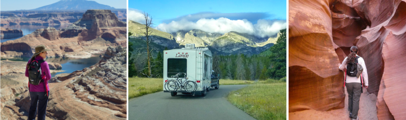
 I love maps. I always look forward to studying an atlas or trail map and plotting out our journey for the next adventure. Hubby and I seem to have a curiosity….. “What’s around the next bend?” It doesn’t seem to matter if we’re driving or hiking, a map piques a curiosity within us. We have to explore, we have to see what’s over the hill or around the corner.
During our first day camped at Blue Mesa, we visited the Elk Creek Visitor Center. We obtained maps on the Curecanti National Recreation Area Colorado and the Black Canyon of the Gunnison. Al and I peruse the maps and a few brochures we picked up. We set aside a day for explorations.

We start at the east end of Blue Mesa Reservoir and work our way westward. We drive through campgrounds making notes for future visits. We stop at picnic areas and scenic overlooks… photo ops, of course.
By the time we reach the far west end of the reservoir, we’re confronted with a decision; do we turn around and return to camp or turn onto Highway 92. Highway 92 has been a road of particular interest to me for several years. Every now and then, when I stare study a map there’s a road that eventually I just have to drive. It’s that curiosity; what does the scenery look like? Is the grass really greener on the other side? Would this be some place I’d like to live?
It was still morning. We’d packed a cooler with lunch and beverages. With the day young, onward we traveled. We agreed to go as far as Hermits Rest, a scenic overlook with picnic tables and restroom. At that point we’ll reassess the day’s travels.
As we turn off highway 50 onto highway 92 we cross the Blue Mesa Damn. On the one side is the Blue Mesa Reservoir and on the other is the Gunnison River – sitting at the waaaay bottom of a deep canyon. This is the beginning of the Black Canyon of the Gunnison. Highway 92 is a well maintained paved road and although assessable to trucks, RV’s, and trailers it can be slow going with all the twists and turns. And then there’s the tourists constantly pulling over to take photographs….I can’t imagine.
Ok, I’ll admit, whenever there was a gravel pull-out, yours truly was jumping out of the vehicle to snap a photo; quite often with hubby yelling out of the window, “Would you please stop getting so close to the edge!” 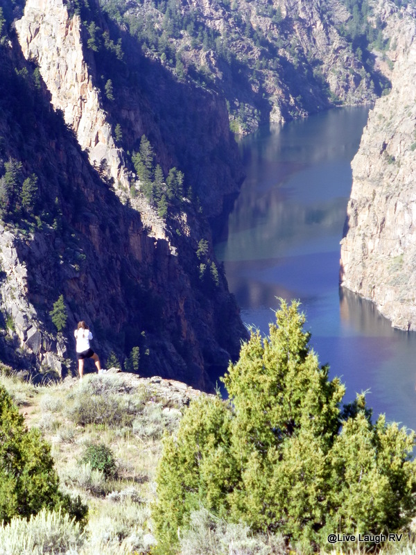
 Our favorite spot the entire day was Pioneer Point. This beautiful scenic overlook was in the process of being improved with a series of trails leading to various canyon ledges. Pretty stone pillars and railings were being installed. Most of the other areas we stopped at offer no safety to the canyon below. This is certainly not a place for kids to get silly….. it’s very much like the Grand Canyon on a much smaller scale.
 From Pioneer Point one can hike and camp down near the river’s edge. Although the water traveling through the Black Canyon is the Gunnison River, at this point the water is called Morrow Point Reservoir. The hike down and back to the water is considered strenuous due to the severe elevation change. If I didn’t have a hidden agenda, we may have tackled the hike down to the river, but there’s a place I have been dying to visit for years….there’s that curiosity thing again. However in today’s adventure, hubby does not share the same curiosity. This calls for a little batting of the eyes accompanied by the look and tilting of the head. You know he can’t resist 😉
We continue down the road toward Hermits Rest. There’s another trail head down to the water along with a campsite. This trail is longer and once again deemed strenuous. We’ll pass. Although the views at Hermits Rest are pretty, the views were still nicer at Pioneer Point.
At Hermits Rest, we stand at the rail in silence admiring the view, there’s a light breeze blowing amidst a gorgeous Colorado blue sky. Here’s my opportunity….. In an ever so sweet voice, I say, “You know hon…… we’ve already traveled this far, we might as well go to the north Rim of the Black Canyon of the Gunnison”. In mid sentence, I attempted to remove my sunglasses so the tilted head, batting of lashes, and sweet tone would be difficult for Al to resist, but I was quickly blinded by the blaring sun. The move was more comical than attractive.
As it was, Al wasn’t even looking at me, he was looking at the bottom of the canyon. He was however listening and questioned, “How far is it to the north rim?” “Hum, I’m not sure. Probably less than an hour. Wouldn’t it be silly of us to have already traveled this far and not go just a little further to see the north rim”, I comment.
Al says, “That was your plan all along, wasn’t it? And you thought I didn’t know what you were up to. You’ve talked about going to the north rim of the Black Canyon of the Gunnison ever since we visited the south rim seven years ago”. Ah….ain’t that sweet? He actually listens to me and he remembered. So off we go, further into the hinterland toward the town of Crawford.

The north rim of the Black Canyon of the Gunnison is very under developed. As a matter of fact, the park entrance is eleven miles off highway 92, the last six miles being gravel. There was no ranger in sight. There’s a station to self pay and pick up a brochure. The campground is big enough for tents and pop up trailers.
Since this is actually a National Park and with Al’s “old fart’s card“, our admittance fee is zero. So we bypass the Iron Ranger and proceed to tour the park. I stop at every designated scenic overlook while Al stays in the car for the most part. We’ve been viewing this canyon from the moment we turned off of highway 50 onto highway 92. So it’s been about three hours of looking into the canyon. Al’s had his fill…. “Yeah, yeah, yeah it’s pretty. Do you have enough photos yet?”
I’m amazed how desolate it is on the north rim. This is a National Park after all. We spent maybe an hour touring the park and saw a total of three other vehicles. Wow, this was like having my own personal National Park. We barely had to share the place. Some of the designated overlooks required a short trail and others were near the gravel road.

Most of the overlooks and trails had no rails. One trail in particular made me rather uncomfortable…. the trails are dirt/gravel, dry and loose. Railings are few and far between. This trail was sloped toward the ledge and with the loose rock underfoot, it presented a heart stopping moment as my right foot started to slide. I caught myself but the heart was pounding ….. an almost p*ss my pants moment. Ah…the call of nature. Hey, no one’s around. I can squat and hover to my hearts content….and the view, oh what a view! In my hover position I admire the view and glance over to the south rim.

The south rim of the Black Canyon of the Gunnison is the popular side of the canyon with a large visitor center. I quickly stand, rearranging my shorts and wonder if they have any of those binocular viewing things that tourists pump quarters into. Feeling confident by privacy wasn’t breached and quite frankly none too concerned, I walked near the ledge. This is so cool. There’s a beauty I can’t put into words. The beauty is extremely difficult to capture on film. The lighting presents a challenge, as does the depth and width of the canyon.

With my thrill of the day behind me, I returned to the vehicle and a patiently waiting husband. No need to worry him with any of today’s antics…..let’s have lunch. It’s 1:00 and we’re starving. There’s no picnic areas with the exception of the campground at the other end of the park. There’s no shade and the sun is strong and hot. So we decide to eat our sandwiches on the go as we meander our way back to highway 92.
I don’t know why, but I’m fascinated by Black Canyon of the Gunnison. I would love to revisit the south rim, but I think I’d better wait awhile before I bring up the subject to hubby who by this point is saying, “Ya seen one canyon, you’ve seen’m all. Yeah, it’s rock all right….ooh, ah, ooh, ah”.

Would I recommend visiting the north rim of the Black Canyon of the Gunnison? No, unless you’re out traveling near Crawford anyway, but it’s not worth going out of the way to visit. I would recommend the south rim. It’s easy to get to off highway 50, but the road does have length restrictions. If you’re only interested in a quick glance, I would highly recommend visiting Pioneer Point. Even Al says he’d go back to Pioneer Point and even consider taking the Curecanti Creek Trail down to the river. I’ll remember that 🙂
All in all, it was a fabulous day. We both had a great time. Yep, I’d say this RVing lifestyle is pretty darn sweet thus far!


I’d go any time of the day, if I get the chance. Way to hold your grounds not pulling back and to some of your camera manueverings. I am a big tourist-kind of traveller, and I always pull over the side of the road when the road is scenic. The overcrowded 😀 park looks so majestic.
LikeLike
Such stunning country and you have captured it beautifully Ingrid. 🙂
LikeLike
Those pictures are just breathtaking, Ingrid. So much depth! I had never even heard of Black Canyon before, so I really enjoyed the photo tour! And I am like you, I could curl up with a good atlas and enjoy just as much as a good book!
LikeLike
The eyelash flutter use to work…not any more..My eyelids are so creped they won’t flutter…and my eyelashes are buried in my eye sockets..LOVED the canyon!
LikeLike
Oh my gosh Donna, you are too funny. The canyon is pretty awesome….regardless of what Al says 😉
LikeLike
Great shots of some stunning scenery but I must admit a few of them made my stomach flip a little. I am also a map person and will be heading off to the map to see where you’ve been as soon as I hit “post comment”. I’m married to the un-map person so sometimes I have to drive and navigate. Since I don’t trust the Garmin, I always plan the route and write it out for Bev, then use the Garmin to alert me to an upcoming turn – as long as it agrees with what I’ve written down that is.
LikeLike
I am so with you on NOT trusting the Garmin…..or in my case my smart phone, which isn’t always very smart. I like to map things out and have a pretty good idea where I’m going.
So you weren’t comfortable with me at the ledge? I really should have taken a photo of my feet to show the extent of my stupidity to capture a photo. Your stomach would’ve have really flipped 🙂
LikeLike
I am little jealous that you made it all the way over to the north rim. We visited the south rim this summer, and while the views were fabulous I kept gazing across at the undeveloped north rim and thinking how I would love to go there. As you know, it was a really far drive though, so I had to be content with the south side along with all the other tourists. I was glad to see your photos. Oh, and there’s nothing like a little squat with a view – I’ve definitely been there before 🙂
LikeLike
You did a great post on the Black Canyon. I can’t remember…..did you guys take the road to the bottom? A friend told me it was worth the drive. Next summer I think we’ll take the Morrow Point Boat Tour through the canyon. We just weren’t at Blue Mesa long enough to do it all and the lack of internet does present a problem. We may just have to steal your spot on Washington Gulch in Crested Butte 😀
LikeLike
We didn’t take the drive all the way to the bottom, but it might have to go on the list for next summer. I also love the idea of a boat tour! We’re planning on going back to Crested Butte next year- probably at the beginning of August. Washington Gulch Rd. was one of the best free spots we’ve ever stayed so I am sure that’s where we’ll end up again. Can’t get enough Colorado!
LikeLike
Hahaha. That is so funny. I used exactly the same wiles on my hubby when we were heading north from Lake Powell and I wanted to go to the North Rim of the Grand Canyon. Worked a treat! And enough photographs? is there such a thing?
LikeLike
No there is never enough photos. Hubby always jokes, “did you bring enough film?” Don’t you just love digital? Sometimes a gals gotta do what a gals gotta do and if a sweet voice and head tilt work….well more power to us 😉
LikeLike
That’s a bit spooky. My hubby says, “Have you run out of film yet?” Haha! Click click click!
LikeLike
Hi Ingrid…your photos are awesome. I haven’t been in Colorado long, and have already fallen in love with it! We have taken several hikes around Durango and yes, did drive to Silverton last Sunday. The Internet here has been way to slow to download any pictures so I haven’t posted yet. It has been raining all day and is even predicted for tomorrow…bummer! Our plans for 2014 include a lot of time in CO. I so want to hike around Ouray and take Pearl( our Jeep ) on the Alpine Loop. Thanks for the comment on good-times-rollin.
LikeLike
Thank you…. the scenery makes it easy to photograph. I certainly understand having internet issues. We’ve embarked on two “easy” 4×4 roads; Last Dollar Road and Owl Creek Pass. Next summer we hope to explore the “moderate” roads like Imogene Pass and Engineer (Alpine loop). It’s so much fun and the views are stunning. You’ll love it!
LikeLike
Beautiful! And how special to have it practically to your yourselves. BC of the G is on our list!
LikeLike
At the south rim, you’re able to drive to the bottom. I have a friend who says it’s beautiful. The other thing we really wanted to do but our friends couldn’t do the hike is the Morrow Point Boat Tour run by the Park Rangers. It’s a 45 minute hike, over 200 steps down to the river then a one and a half hour boat trip through the canyon. That’s on next summers list. That list keeps getting longer 🙂
LikeLike
Ingrid, gorgeous photo of the Columbine! Of course all yours photos are beautiful. We do live in a beautiful state!
LikeLike
Thank you. Because the western slope received a fair amount of moisture this summer, the wildflowers in Crested Butte and Ouray were beautiful and long lasting.
LikeLike
Great post, Ingrid :)!! I would love to do some hiking in the spots you were at!!
LikeLike
You’d love the trails. We’ll need to chat over drinks in AZ. I’ll fill you in on all the details!
LikeLike
What a good sport you have following your trail….too cute! If anyone is going to scope out a spot to hike, you would be the to-go person that’s for sure! I thought of hiking a cornfield or two, but gave up and saving my energy for some real trails! Fantastic photography!
LikeLike
Why thank you. Anytime you’d like a personal tour of Colorado, let me know. We just scoped out 3 more gorgeous campgrounds this week…..we are too big, but you’re not 🙂
LikeLike
Happy Exploring – Beautiful Captures:) Mr. Craves and I joke that we make frequent stops, especially with the scenic view points when road tripping – ha! Happy Tuesday.
LikeLike
Ya gotta stop and smell the roses or at least water them 😉 This slow meandering travel is so much more enjoyable than the hurry up and get there 🙂
LikeLike
Lovely photos of an awesome place…thank you.
LikeLike
Thank you. We’re certainly enjoying the beauty Colorado has to offer.
LikeLike
Thanks for the laugh! Outstanding post!! I can so see and hear myself saying and acting the same way. John would have responded the exact same way since I usually have an undisclosed agenda:) John does the same stay in the car thing after a while, especially if it involves animals and strange saquaro!
We do have some beautiful “facilities” to hover in, don’t we;) We both used nature while below the Gemini Bridges in Moab. Then, when we drove out to see top view, we looked down with the binoculars. John says, isn’t that the tree you were beyond just a little bit ago? Gee, I hope no one was up there with their binoculars!!
Love the beautiful canyons!!
LikeLike
Glad you enjoyed. I see no point in being uncomfortable by holding off that squat, and you are so right about the beautiful facilities. You gotta laugh and have a good time…..that’s what’s it’s all about. You planning on Colorado next summer? There’s some trails and 4×4 roads waiting for ya!
LikeLike
We may not get to Colorado next summer. We are thinking of moving west next year (leaving here early May) by coming across Canada, heading into the northern Rockies. No one I know visits the middle of Canada. I want to see places I only hear about mainly from ice hockey. I saw an advertisement for the Yellowhead Hwy and got this bug to take it. But who knows how long that will take. But never fear, CO is most definitely in the future plans. Too many have posted from there this summer. Mark is killing me! I need to get to Ouray!!!!
LikeLike
Going across Canada sounds like tons of fun. Mark’s photos are amazing as is the country around here. We’ll be hopefully spending the winter getting in shape to tackle some of the hikes he and Bobbie do next summer.
LikeLike
You two must be a hoot to be around from the way that you describe your conversations! You must also be one of the very rare women who can even read a map. let alone visualize the scenery along a route. At least that’s been my experience. Oh, great scenery as well!
LikeLike
Life’s too short not to have a good time. We don’t take ourselves to seriously and usually find humor in most situations. I usually do the navigating and don’t get lost…..I do get turned around, but never lost…lol. We have a little role reversal….Hubby will be the first to stop and ask for directions. Beautiful country indeed.
LikeLike
I am so jealous!!!!!!! You get to go and photograph the bestest places! I have never been to Colorado and now I’m all hyped up about it.
LikeLike
You know I keep telling you I see an RV in your future….LOL. My photos really don’t do the true beauty of this place justice. I’ll keep trying though!
LikeLike
These are just breath taking photos… but one question, and I have asked it of Linda… if you want to go somewhere why not just come straight out and say so.?? I am tortured by the eyelash flutter, tilted head and hints so long even an idiot would understand what is wanted… just come on out and say where you want to go… all that can happen is we say NO… I love this blog and I love the visit you have just had, and I’m sure Al did too, he might not admit it, but he did…
LikeLike
See….you said the magic word “no”….thus the eyelash flutter, etc. Thus we don’t give you boys a chance to say no. Oh, and Al did indeed have a wonderful time. The day just got a little longer than his liking. After 3 hours of viewing the canyon, I’ll admit it all started looking alike 🙂
LikeLike
Fabulous day indeed! And I have a visual of you doing your business with a view! how cute.Very beautiful captures,great photos! Cant wait to be in CO one day and savor for ourselves what you have been sharing us.
LikeLike
Oh dear, a visual? LOL I promise, you and Steve will love Colorado. What are the summer plans for 2014? This winter I think we’ll make it as far east as Rockport, Texas.
LikeLike
No plans yet but we will probably heading north, maybe Michigan?
LikeLike
Remember Sleeping Bear Sand Dunes and Mackinac Island 🙂 oh and Picture Rock
LikeLike
oh yes, Mackinac Island has been planted on my brain since you mentioned it.
LikeLike